You are here: Home > Network List > UW - Pacific Northwest Regional Seismic Network Stations List
> Station UMAT Pilot Rock, OR, USA > Earthquake Result Viewer
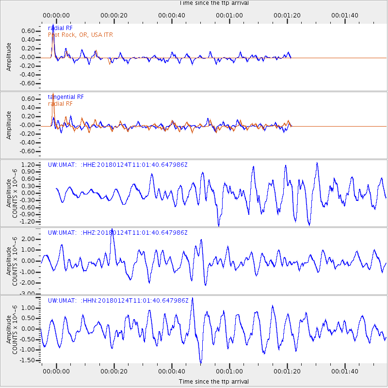
UMAT Pilot Rock, OR, USA - Earthquake Result Viewer
*The percent match for this event was below the threshold and hence no stack was calculated.
| Earthquake location: |
Hokkaido, Japan Region |
| Earthquake latitude/longitude: |
41.1/142.3 |
| Earthquake time(UTC): |
2018/01/24 (024) 10:51:20 GMT |
| Earthquake Depth: |
40 km |
| Earthquake Magnitude: |
6.2 Mww |
| Earthquake Catalog/Contributor: |
NEIC PDE/us |
|
| Network: |
UW Pacific Northwest Regional Seismic Network |
| Station: |
UMAT Pilot Rock, OR, USA |
| Lat/Lon: |
45.29 N/118.96 W |
| Elevation: |
1318 m |
|
| Distance: |
67.5 deg |
| Az: |
49.048 deg |
| Baz: |
306.066 deg |
| Ray Param: |
$rayparam |
*The percent match for this event was below the threshold and hence was not used in the summary stack. |
|
| Radial Match: |
79.91518 % |
| Radial Bump: |
223 |
| Transverse Match: |
59.58348 % |
| Transverse Bump: |
322 |
| SOD ConfigId: |
13570011 |
| Insert Time: |
2019-04-29 15:42:45.980 +0000 |
| GWidth: |
2.5 |
| Max Bumps: |
400 |
| Tol: |
0.001 |
|
Signal To Noise
| Channel | StoN | STA | LTA |
| UW:UMAT: :HHZ:20180124T11:01:40.647986Z | 2.3256257 | 7.5248494E-7 | 3.2356238E-7 |
| UW:UMAT: :HHN:20180124T11:01:40.647986Z | 1.8530635 | 4.9089385E-7 | 2.6490935E-7 |
| UW:UMAT: :HHE:20180124T11:01:40.647986Z | 2.161271 | 3.831601E-7 | 1.7728462E-7 |
| Arrivals |
| Ps | |
| PpPs | |
| PsPs/PpSs | |


