You are here: Home > Network List > CI - Caltech Regional Seismic Network Stations List
> Station IRM Iron Mountain Pumping Station, Eagle Mtn., CA, USA > Earthquake Result Viewer
IRM Iron Mountain Pumping Station, Eagle Mtn., CA, USA - Earthquake Result Viewer

| Earthquake location: |
Fox Islands, Aleutian Islands |
| Earthquake latitude/longitude: |
52.5/-168.0 |
| Earthquake time(UTC): |
2007/07/15 (196) 13:08:00 GMT |
| Earthquake Depth: |
10 km |
| Earthquake Magnitude: |
5.8 MB, 5.9 MS, 6.1 MW, 6.0 MW |
| Earthquake Catalog/Contributor: |
WHDF/NEIC |
|
| Network: |
CI Caltech Regional Seismic Network |
| Station: |
IRM Iron Mountain Pumping Station, Eagle Mtn., CA, USA |
| Lat/Lon: |
34.16 N/115.15 W |
| Elevation: |
567 m |
|
| Distance: |
41.6 deg |
| Az: |
94.658 deg |
| Baz: |
312.682 deg |
| Ray Param: |
0.07370582 |
| Estimated Moho Depth: |
66.5 km |
| Estimated Crust Vp/Vs: |
1.80 |
| Assumed Crust Vp: |
6.276 km/s |
| Estimated Crust Vs: |
3.491 km/s |
| Estimated Crust Poisson's Ratio: |
0.28 |
|
| Radial Match: |
95.99826 % |
| Radial Bump: |
320 |
| Transverse Match: |
90.22652 % |
| Transverse Bump: |
400 |
| SOD ConfigId: |
2564 |
| Insert Time: |
2010-02-26 01:45:54.213 +0000 |
| GWidth: |
2.5 |
| Max Bumps: |
400 |
| Tol: |
0.001 |
|
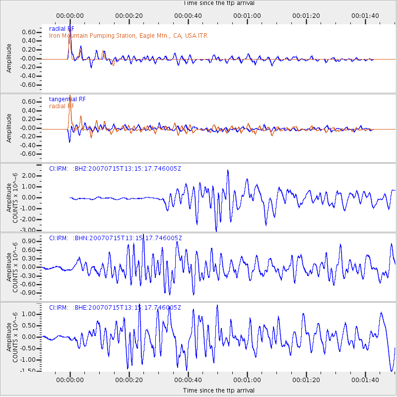
Signal To Noise
| Channel | StoN | STA | LTA |
| CI:IRM: :BHN:20070715T13:15:17.746005Z | 3.3572524 | 1.5400127E-7 | 4.5871225E-8 |
| CI:IRM: :BHE:20070715T13:15:17.746005Z | 3.7677007 | 2.0089209E-7 | 5.3319546E-8 |
| CI:IRM: :BHZ:20070715T13:15:17.746005Z | 7.9241953 | 4.6740902E-7 | 5.8985044E-8 |
| Arrivals |
| Ps | 9.0 SECOND |
| PpPs | 28 SECOND |
| PsPs/PpSs | 37 SECOND |


