You are here: Home > Network List > TA - USArray Transportable Network (new EarthScope stations) Stations List
> Station B18K Kokolik River, AK, USA > Earthquake Result Viewer
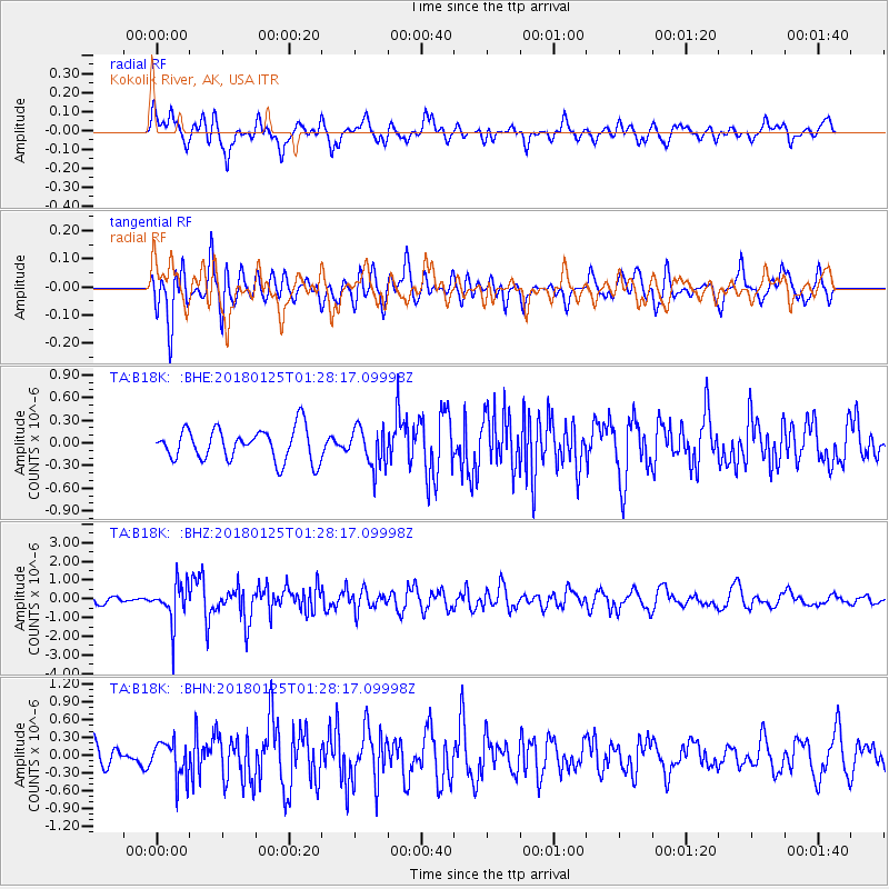
B18K Kokolik River, AK, USA - Earthquake Result Viewer
*The percent match for this event was below the threshold and hence no stack was calculated.
| Earthquake location: |
Nicobar Islands, India Region |
| Earthquake latitude/longitude: |
8.3/91.8 |
| Earthquake time(UTC): |
2018/01/25 (025) 01:15:58 GMT |
| Earthquake Depth: |
10 km |
| Earthquake Magnitude: |
5.9 Mww |
| Earthquake Catalog/Contributor: |
NEIC PDE/us |
|
| Network: |
TA USArray Transportable Network (new EarthScope stations) |
| Station: |
B18K Kokolik River, AK, USA |
| Lat/Lon: |
69.36 N/161.80 W |
| Elevation: |
222 m |
|
| Distance: |
88.0 deg |
| Az: |
19.893 deg |
| Baz: |
288.202 deg |
| Ray Param: |
$rayparam |
*The percent match for this event was below the threshold and hence was not used in the summary stack. |
|
| Radial Match: |
73.375626 % |
| Radial Bump: |
400 |
| Transverse Match: |
61.366467 % |
| Transverse Bump: |
400 |
| SOD ConfigId: |
13570011 |
| Insert Time: |
2019-04-29 15:46:43.173 +0000 |
| GWidth: |
2.5 |
| Max Bumps: |
400 |
| Tol: |
0.001 |
|
Signal To Noise
| Channel | StoN | STA | LTA |
| TA:B18K: :BHZ:20180125T01:28:17.09998Z | 3.8850303 | 1.0576891E-6 | 2.7224735E-7 |
| TA:B18K: :BHN:20180125T01:28:17.09998Z | 1.6194283 | 3.083366E-7 | 1.9039842E-7 |
| TA:B18K: :BHE:20180125T01:28:17.09998Z | 1.2282928 | 2.6080167E-7 | 2.1232857E-7 |
| Arrivals |
| Ps | |
| PpPs | |
| PsPs/PpSs | |


