You are here: Home > Network List > TA - USArray Transportable Network (new EarthScope stations) Stations List
> Station F21K Alatna River, AK, USA > Earthquake Result Viewer
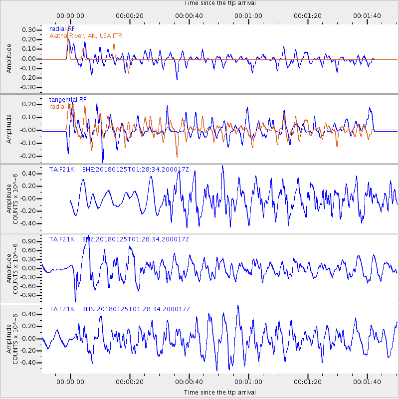
F21K Alatna River, AK, USA - Earthquake Result Viewer
*The percent match for this event was below the threshold and hence no stack was calculated.
| Earthquake location: |
Nicobar Islands, India Region |
| Earthquake latitude/longitude: |
8.3/91.8 |
| Earthquake time(UTC): |
2018/01/25 (025) 01:15:58 GMT |
| Earthquake Depth: |
10 km |
| Earthquake Magnitude: |
5.9 Mww |
| Earthquake Catalog/Contributor: |
NEIC PDE/us |
|
| Network: |
TA USArray Transportable Network (new EarthScope stations) |
| Station: |
F21K Alatna River, AK, USA |
| Lat/Lon: |
67.22 N/153.48 W |
| Elevation: |
597 m |
|
| Distance: |
91.7 deg |
| Az: |
20.72 deg |
| Baz: |
295.929 deg |
| Ray Param: |
$rayparam |
*The percent match for this event was below the threshold and hence was not used in the summary stack. |
|
| Radial Match: |
60.574696 % |
| Radial Bump: |
400 |
| Transverse Match: |
68.60864 % |
| Transverse Bump: |
400 |
| SOD ConfigId: |
13570011 |
| Insert Time: |
2019-04-29 15:47:00.020 +0000 |
| GWidth: |
2.5 |
| Max Bumps: |
400 |
| Tol: |
0.001 |
|
Signal To Noise
| Channel | StoN | STA | LTA |
| TA:F21K: :BHZ:20180125T01:28:34.200017Z | 3.829396 | 4.252278E-7 | 1.1104304E-7 |
| TA:F21K: :BHN:20180125T01:28:34.200017Z | 1.0279362 | 9.4524886E-8 | 9.195598E-8 |
| TA:F21K: :BHE:20180125T01:28:34.200017Z | 1.1124076 | 1.4379825E-7 | 1.2926759E-7 |
| Arrivals |
| Ps | |
| PpPs | |
| PsPs/PpSs | |


