You are here: Home > Network List > 5H - Central Virginia and South Carolina seismic monitoring experiment Stations List
> Station ANNI Yanceyville, VA > Earthquake Result Viewer
ANNI Yanceyville, VA - Earthquake Result Viewer
| Earthquake location: |
Komandorskiye Ostrova Region |
| Earthquake latitude/longitude: |
55.4/166.5 |
| Earthquake time(UTC): |
2018/01/25 (025) 02:10:33 GMT |
| Earthquake Depth: |
8.8 km |
| Earthquake Magnitude: |
6.2 Mww |
| Earthquake Catalog/Contributor: |
NEIC PDE/us |
|
| Network: |
5H Central Virginia and South Carolina seismic monitoring experiment |
| Station: |
ANNI Yanceyville, VA |
| Lat/Lon: |
37.94 N/77.97 W |
| Elevation: |
93 m |
|
| Distance: |
72.0 deg |
| Az: |
48.578 deg |
| Baz: |
327.253 deg |
| Ray Param: |
0.053925145 |
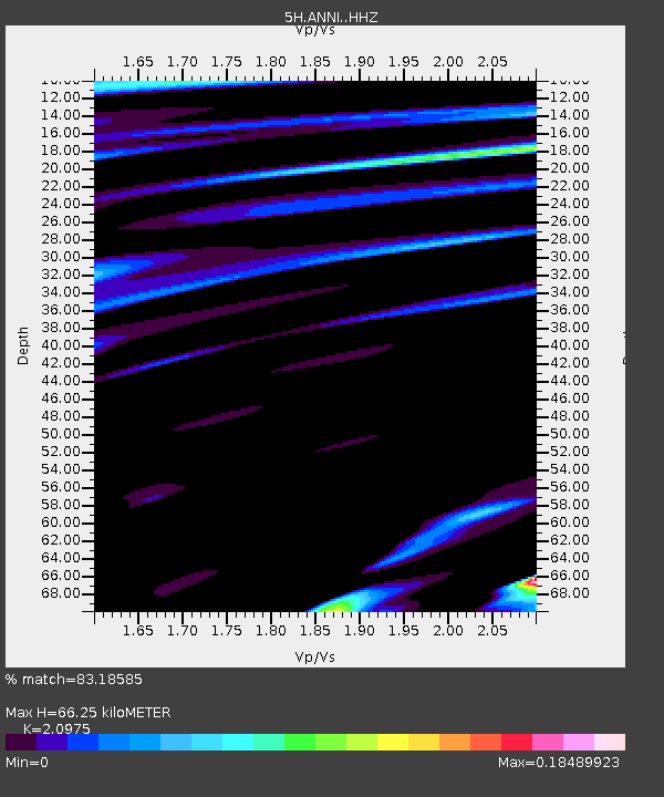
| Estimated Moho Depth: |
66.25 km |
| Estimated Crust Vp/Vs: |
2.10 |
| Assumed Crust Vp: |
6.565 km/s |
| Estimated Crust Vs: |
3.13 km/s |
| Estimated Crust Poisson's Ratio: |
0.35 |
|
| Radial Match: |
83.18585 % |
| Radial Bump: |
400 |
| Transverse Match: |
78.68457 % |
| Transverse Bump: |
400 |
| SOD ConfigId: |
13570011 |
| Insert Time: |
2019-04-29 15:48:27.318 +0000 |
| GWidth: |
2.5 |
| Max Bumps: |
400 |
| Tol: |
0.001 |
|

Signal To Noise
| Channel | StoN | STA | LTA |
| 5H:ANNI: :HHZ:20180125T02:21:26.960024Z | 5.7548466 | 1.4342102E-6 | 2.4921778E-7 |
| 5H:ANNI: :HHN:20180125T02:21:26.960024Z | 1.8105333 | 4.3464635E-7 | 2.400654E-7 |
| 5H:ANNI: :HHE:20180125T02:21:26.960024Z | 0.87085223 | 1.8727182E-7 | 2.1504431E-7 |
| Arrivals |
| Ps | 11 SECOND |
| PpPs | 30 SECOND |
| PsPs/PpSs | 42 SECOND |


