You are here: Home > Network List > CI - Caltech Regional Seismic Network Stations List
> Station IRM Iron Mountain Pumping Station, Eagle Mtn., CA, USA > Earthquake Result Viewer
IRM Iron Mountain Pumping Station, Eagle Mtn., CA, USA - Earthquake Result Viewer

| Earthquake location: |
Near Coast Of Guatemala |
| Earthquake latitude/longitude: |
13.6/-90.6 |
| Earthquake time(UTC): |
2007/06/13 (164) 19:29:40 GMT |
| Earthquake Depth: |
23 km |
| Earthquake Magnitude: |
5.9 MB, 6.5 MS, 6.7 MW, 6.5 MW |
| Earthquake Catalog/Contributor: |
WHDF/NEIC |
|
| Network: |
CI Caltech Regional Seismic Network |
| Station: |
IRM Iron Mountain Pumping Station, Eagle Mtn., CA, USA |
| Lat/Lon: |
34.16 N/115.15 W |
| Elevation: |
567 m |
|
| Distance: |
30.3 deg |
| Az: |
316.898 deg |
| Baz: |
126.741 deg |
| Ray Param: |
0.079364605 |
| Estimated Moho Depth: |
19.5 km |
| Estimated Crust Vp/Vs: |
2.09 |
| Assumed Crust Vp: |
6.276 km/s |
| Estimated Crust Vs: |
3.01 km/s |
| Estimated Crust Poisson's Ratio: |
0.35 |
|
| Radial Match: |
95.02972 % |
| Radial Bump: |
315 |
| Transverse Match: |
80.42808 % |
| Transverse Bump: |
400 |
| SOD ConfigId: |
2564 |
| Insert Time: |
2010-02-26 01:46:00.102 +0000 |
| GWidth: |
2.5 |
| Max Bumps: |
400 |
| Tol: |
0.001 |
|
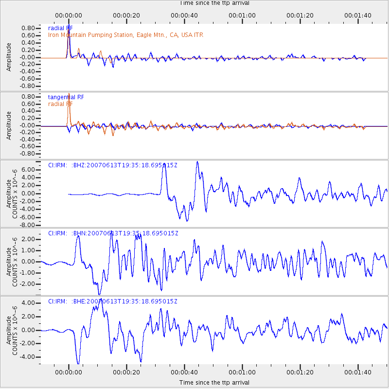
Signal To Noise
| Channel | StoN | STA | LTA |
| CI:IRM: :BHN:20070613T19:35:18.695015Z | 4.6925454 | 1.0478383E-6 | 2.232985E-7 |
| CI:IRM: :BHE:20070613T19:35:18.695015Z | 12.636824 | 2.2465113E-6 | 1.77775E-7 |
| CI:IRM: :BHZ:20070613T19:35:18.695015Z | 27.90938 | 3.5584621E-6 | 1.2750058E-7 |
| Arrivals |
| Ps | 3.6 SECOND |
| PpPs | 9.0 SECOND |
| PsPs/PpSs | 13 SECOND |


