You are here: Home > Network List > GO - National Seismic Network of Georgia Stations List
> Station AKH Akhalkalaki > Earthquake Result Viewer
AKH Akhalkalaki - Earthquake Result Viewer
| Earthquake location: |
Komandorskiye Ostrova Region |
| Earthquake latitude/longitude: |
55.4/166.5 |
| Earthquake time(UTC): |
2018/01/25 (025) 02:10:33 GMT |
| Earthquake Depth: |
8.8 km |
| Earthquake Magnitude: |
6.2 Mww |
| Earthquake Catalog/Contributor: |
NEIC PDE/us |
|
| Network: |
GO National Seismic Network of Georgia |
| Station: |
AKH Akhalkalaki |
| Lat/Lon: |
41.41 N/43.49 E |
| Elevation: |
1720 m |
|
| Distance: |
72.1 deg |
| Az: |
318.462 deg |
| Baz: |
30.188 deg |
| Ray Param: |
0.053900402 |
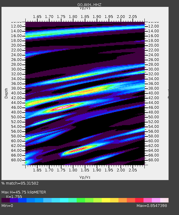
| Estimated Moho Depth: |
45.75 km |
| Estimated Crust Vp/Vs: |
1.75 |
| Assumed Crust Vp: |
6.419 km/s |
| Estimated Crust Vs: |
3.658 km/s |
| Estimated Crust Poisson's Ratio: |
0.26 |
|
| Radial Match: |
85.31582 % |
| Radial Bump: |
400 |
| Transverse Match: |
71.87851 % |
| Transverse Bump: |
367 |
| SOD ConfigId: |
13570011 |
| Insert Time: |
2019-04-29 15:51:49.838 +0000 |
| GWidth: |
2.5 |
| Max Bumps: |
400 |
| Tol: |
0.001 |
|

Signal To Noise
| Channel | StoN | STA | LTA |
| GO:AKH: :HHZ:20180125T02:21:26.960024Z | 4.5677285 | 1.51363E-6 | 3.3137476E-7 |
| GO:AKH: :HHN:20180125T02:21:26.960024Z | 2.274897 | 8.736085E-7 | 3.8402106E-7 |
| GO:AKH: :HHE:20180125T02:21:26.960024Z | 0.81742024 | 3.3301856E-7 | 4.0740193E-7 |
| Arrivals |
| Ps | 5.6 SECOND |
| PpPs | 19 SECOND |
| PsPs/PpSs | 25 SECOND |


