You are here: Home > Network List > TA - USArray Transportable Network (new EarthScope stations) Stations List
> Station O23A Lake Granby, Granby, CO, USA > Earthquake Result Viewer
O23A Lake Granby, Granby, CO, USA - Earthquake Result Viewer
| Earthquake location: |
Off East Coast Of Honshu, Japan |
| Earthquake latitude/longitude: |
37.6/142.2 |
| Earthquake time(UTC): |
2008/07/19 (201) 02:39:28 GMT |
| Earthquake Depth: |
22 km |
| Earthquake Magnitude: |
6.2 MB, 7.0 MS, 7.0 MW, 6.9 MW |
| Earthquake Catalog/Contributor: |
WHDF/NEIC |
|
| Network: |
TA USArray Transportable Network (new EarthScope stations) |
| Station: |
O23A Lake Granby, Granby, CO, USA |
| Lat/Lon: |
40.21 N/105.92 W |
| Elevation: |
2635 m |
|
| Distance: |
80.6 deg |
| Az: |
46.088 deg |
| Baz: |
311.612 deg |
| Ray Param: |
0.048154343 |
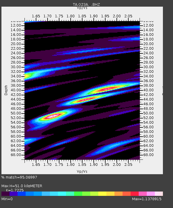
| Estimated Moho Depth: |
51.0 km |
| Estimated Crust Vp/Vs: |
1.72 |
| Assumed Crust Vp: |
6.306 km/s |
| Estimated Crust Vs: |
3.661 km/s |
| Estimated Crust Poisson's Ratio: |
0.25 |
|
| Radial Match: |
95.06997 % |
| Radial Bump: |
400 |
| Transverse Match: |
94.18103 % |
| Transverse Bump: |
400 |
| SOD ConfigId: |
2504 |
| Insert Time: |
2010-03-06 08:24:40.421 +0000 |
| GWidth: |
2.5 |
| Max Bumps: |
400 |
| Tol: |
0.001 |
|

Signal To Noise
| Channel | StoN | STA | LTA |
| TA:O23A: :BHZ:20080719T02:51:08.048999Z | 7.9238644 | 6.3213594E-7 | 7.977622E-8 |
| TA:O23A: :BHN:20080719T02:51:08.048999Z | 2.7144253 | 1.6091381E-7 | 5.928099E-8 |
| TA:O23A: :BHE:20080719T02:51:08.048999Z | 2.7928264 | 1.7856684E-7 | 6.393768E-8 |
| Arrivals |
| Ps | 6.0 SECOND |
| PpPs | 21 SECOND |
| PsPs/PpSs | 27 SECOND |


