You are here: Home > Network List > TA - USArray Transportable Network (new EarthScope stations) Stations List
> Station O23A Lake Granby, Granby, CO, USA > Earthquake Result Viewer
O23A Lake Granby, Granby, CO, USA - Earthquake Result Viewer

| Earthquake location: |
Lake Baykal Region, Russia |
| Earthquake latitude/longitude: |
51.6/104.2 |
| Earthquake time(UTC): |
2008/08/27 (240) 01:35:32 GMT |
| Earthquake Depth: |
16 km |
| Earthquake Magnitude: |
5.8 MB, 6.2 MS, 6.2 MW, 6.2 MW |
| Earthquake Catalog/Contributor: |
WHDF/NEIC |
|
| Network: |
TA USArray Transportable Network (new EarthScope stations) |
| Station: |
O23A Lake Granby, Granby, CO, USA |
| Lat/Lon: |
40.21 N/105.92 W |
| Elevation: |
2635 m |
|
| Distance: |
84.9 deg |
| Az: |
22.664 deg |
| Baz: |
341.713 deg |
| Ray Param: |
0.04516309 |
| Estimated Moho Depth: |
20.75 km |
| Estimated Crust Vp/Vs: |
1.97 |
| Assumed Crust Vp: |
6.306 km/s |
| Estimated Crust Vs: |
3.197 km/s |
| Estimated Crust Poisson's Ratio: |
0.33 |
|
| Radial Match: |
80.39343 % |
| Radial Bump: |
400 |
| Transverse Match: |
80.98839 % |
| Transverse Bump: |
400 |
| SOD ConfigId: |
2504 |
| Insert Time: |
2010-03-06 08:24:55.374 +0000 |
| GWidth: |
2.5 |
| Max Bumps: |
400 |
| Tol: |
0.001 |
|
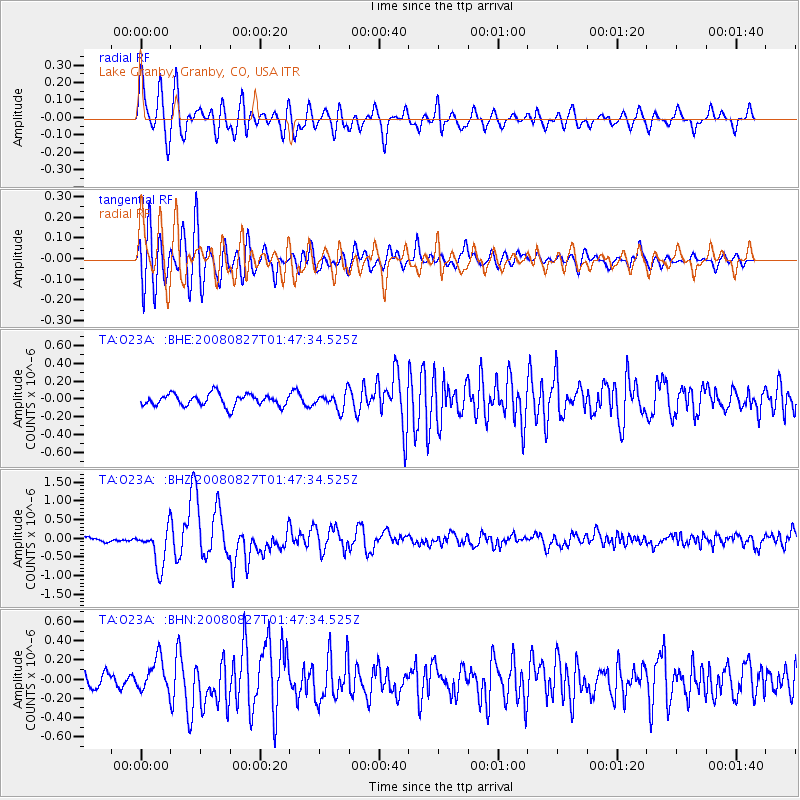
Signal To Noise
| Channel | StoN | STA | LTA |
| TA:O23A: :BHZ:20080827T01:47:34.525Z | 7.5401154 | 5.1356415E-7 | 6.8110914E-8 |
| TA:O23A: :BHN:20080827T01:47:34.525Z | 2.50492 | 1.6520683E-7 | 6.595293E-8 |
| TA:O23A: :BHE:20080827T01:47:34.525Z | 1.3879927 | 9.371723E-8 | 6.751998E-8 |
| Arrivals |
| Ps | 3.3 SECOND |
| PpPs | 9.6 SECOND |
| PsPs/PpSs | 13 SECOND |


