You are here: Home > Network List > TA - USArray Transportable Network (new EarthScope stations) Stations List
> Station O23A Lake Granby, Granby, CO, USA > Earthquake Result Viewer
O23A Lake Granby, Granby, CO, USA - Earthquake Result Viewer
| Earthquake location: |
Tonga Islands |
| Earthquake latitude/longitude: |
-20.8/-174.3 |
| Earthquake time(UTC): |
2009/07/30 (211) 20:05:34 GMT |
| Earthquake Depth: |
10 km |
| Earthquake Magnitude: |
5.9 MB, 5.7 MS, 5.8 MW, 5.7 MW |
| Earthquake Catalog/Contributor: |
WHDF/NEIC |
|
| Network: |
TA USArray Transportable Network (new EarthScope stations) |
| Station: |
O23A Lake Granby, Granby, CO, USA |
| Lat/Lon: |
40.21 N/105.92 W |
| Elevation: |
2635 m |
|
| Distance: |
87.9 deg |
| Az: |
45.414 deg |
| Baz: |
240.44 deg |
| Ray Param: |
0.04299777 |
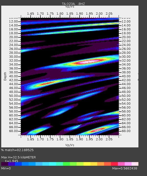
| Estimated Moho Depth: |
32.5 km |
| Estimated Crust Vp/Vs: |
1.95 |
| Assumed Crust Vp: |
6.306 km/s |
| Estimated Crust Vs: |
3.242 km/s |
| Estimated Crust Poisson's Ratio: |
0.32 |
|
| Radial Match: |
82.169525 % |
| Radial Bump: |
400 |
| Transverse Match: |
72.3999 % |
| Transverse Bump: |
400 |
| SOD ConfigId: |
2622 |
| Insert Time: |
2010-03-06 08:25:14.332 +0000 |
| GWidth: |
2.5 |
| Max Bumps: |
400 |
| Tol: |
0.001 |
|

Signal To Noise
| Channel | StoN | STA | LTA |
| TA:O23A: :BHZ:20090730T20:17:53.075022Z | 5.4005775 | 2.5203198E-7 | 4.6667598E-8 |
| TA:O23A: :BHN:20090730T20:17:53.075022Z | 1.5804173 | 7.456889E-8 | 4.718304E-8 |
| TA:O23A: :BHE:20090730T20:17:53.075022Z | 1.4568129 | 8.359678E-8 | 5.738334E-8 |
| Arrivals |
| Ps | 5.0 SECOND |
| PpPs | 15 SECOND |
| PsPs/PpSs | 20 SECOND |


