You are here: Home > Network List > RV - Regional Alberta Seismic Observatory for Earthquake Studies Network Stations List
> Station KIMIA Kimiwan Lookout Tower, AB > Earthquake Result Viewer
KIMIA Kimiwan Lookout Tower, AB - Earthquake Result Viewer
| Earthquake location: |
Komandorskiye Ostrova Region |
| Earthquake latitude/longitude: |
55.4/166.5 |
| Earthquake time(UTC): |
2018/01/25 (025) 02:10:33 GMT |
| Earthquake Depth: |
8.8 km |
| Earthquake Magnitude: |
6.2 Mww |
| Earthquake Catalog/Contributor: |
NEIC PDE/us |
|
| Network: |
RV Regional Alberta Seismic Observatory for Earthquake Studies Network |
| Station: |
KIMIA Kimiwan Lookout Tower, AB |
| Lat/Lon: |
55.99 N/116.61 W |
| Elevation: |
764 m |
|
| Distance: |
41.2 deg |
| Az: |
56.129 deg |
| Baz: |
302.554 deg |
| Ray Param: |
0.07392336 |
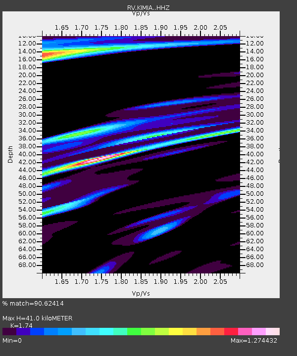
| Estimated Moho Depth: |
41.0 km |
| Estimated Crust Vp/Vs: |
1.74 |
| Assumed Crust Vp: |
6.426 km/s |
| Estimated Crust Vs: |
3.693 km/s |
| Estimated Crust Poisson's Ratio: |
0.25 |
|
| Radial Match: |
90.62414 % |
| Radial Bump: |
393 |
| Transverse Match: |
60.167027 % |
| Transverse Bump: |
400 |
| SOD ConfigId: |
13570011 |
| Insert Time: |
2019-04-29 15:57:22.842 +0000 |
| GWidth: |
2.5 |
| Max Bumps: |
400 |
| Tol: |
0.001 |
|

Signal To Noise
| Channel | StoN | STA | LTA |
| RV:KIMIA: :HHZ:20180125T02:17:48.260012Z | 6.5992985 | 2.6275984E-6 | 3.9816328E-7 |
| RV:KIMIA: :HHN:20180125T02:17:48.260012Z | 2.4398317 | 1.7267656E-6 | 7.077397E-7 |
| RV:KIMIA: :HHE:20180125T02:17:48.260012Z | 2.1170552 | 1.3331438E-6 | 6.297161E-7 |
| Arrivals |
| Ps | 5.1 SECOND |
| PpPs | 16 SECOND |
| PsPs/PpSs | 21 SECOND |


