You are here: Home > Network List > TA - USArray Transportable Network (new EarthScope stations) Stations List
> Station 121A Cookes Peak, Deming, NM, USA > Earthquake Result Viewer
121A Cookes Peak, Deming, NM, USA - Earthquake Result Viewer
| Earthquake location: |
Komandorskiye Ostrova Region |
| Earthquake latitude/longitude: |
55.4/166.5 |
| Earthquake time(UTC): |
2018/01/25 (025) 02:10:33 GMT |
| Earthquake Depth: |
8.8 km |
| Earthquake Magnitude: |
6.2 Mww |
| Earthquake Catalog/Contributor: |
NEIC PDE/us |
|
| Network: |
TA USArray Transportable Network (new EarthScope stations) |
| Station: |
121A Cookes Peak, Deming, NM, USA |
| Lat/Lon: |
32.53 N/107.79 W |
| Elevation: |
1652 m |
|
| Distance: |
61.6 deg |
| Az: |
73.239 deg |
| Baz: |
319.718 deg |
| Ray Param: |
0.06076464 |
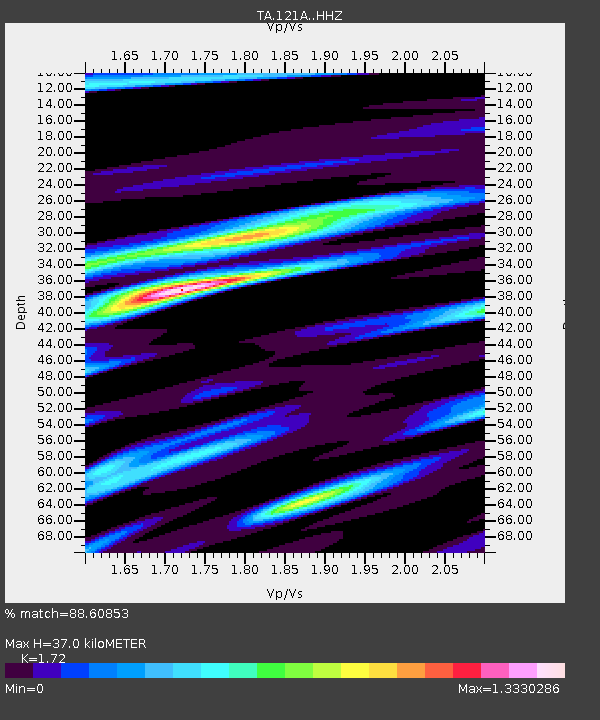
| Estimated Moho Depth: |
37.0 km |
| Estimated Crust Vp/Vs: |
1.72 |
| Assumed Crust Vp: |
6.502 km/s |
| Estimated Crust Vs: |
3.78 km/s |
| Estimated Crust Poisson's Ratio: |
0.24 |
|
| Radial Match: |
88.60853 % |
| Radial Bump: |
373 |
| Transverse Match: |
79.189995 % |
| Transverse Bump: |
400 |
| SOD ConfigId: |
13570011 |
| Insert Time: |
2019-04-29 15:57:48.680 +0000 |
| GWidth: |
2.5 |
| Max Bumps: |
400 |
| Tol: |
0.001 |
|

Signal To Noise
| Channel | StoN | STA | LTA |
| TA:121A: :HHZ:20180125T02:20:20.979983Z | 0.54911834 | 1.6972687E-7 | 3.090898E-7 |
| TA:121A: :HHN:20180125T02:20:20.979983Z | 0.5813885 | 1.340305E-7 | 2.3053518E-7 |
| TA:121A: :HHE:20180125T02:20:20.979983Z | 1.9105344 | 2.6304696E-7 | 1.3768239E-7 |
| Arrivals |
| Ps | 4.3 SECOND |
| PpPs | 15 SECOND |
| PsPs/PpSs | 19 SECOND |


