You are here: Home > Network List > TA - USArray Transportable Network (new EarthScope stations) Stations List
> Station 109C Camp Elliot, Mirimar, CA, USA > Earthquake Result Viewer
109C Camp Elliot, Mirimar, CA, USA - Earthquake Result Viewer

| Earthquake location: |
Komandorskiye Ostrova Region |
| Earthquake latitude/longitude: |
55.4/166.5 |
| Earthquake time(UTC): |
2018/01/25 (025) 02:10:33 GMT |
| Earthquake Depth: |
8.8 km |
| Earthquake Magnitude: |
6.2 Mww |
| Earthquake Catalog/Contributor: |
NEIC PDE/us |
|
| Network: |
TA USArray Transportable Network (new EarthScope stations) |
| Station: |
109C Camp Elliot, Mirimar, CA, USA |
| Lat/Lon: |
32.89 N/117.11 W |
| Elevation: |
150 m |
|
| Distance: |
56.2 deg |
| Az: |
79.881 deg |
| Baz: |
318.135 deg |
| Ray Param: |
0.06431396 |
| Estimated Moho Depth: |
18.25 km |
| Estimated Crust Vp/Vs: |
1.76 |
| Assumed Crust Vp: |
6.264 km/s |
| Estimated Crust Vs: |
3.554 km/s |
| Estimated Crust Poisson's Ratio: |
0.26 |
|
| Radial Match: |
88.29296 % |
| Radial Bump: |
261 |
| Transverse Match: |
80.83821 % |
| Transverse Bump: |
400 |
| SOD ConfigId: |
13570011 |
| Insert Time: |
2019-04-29 15:57:48.749 +0000 |
| GWidth: |
2.5 |
| Max Bumps: |
400 |
| Tol: |
0.001 |
|
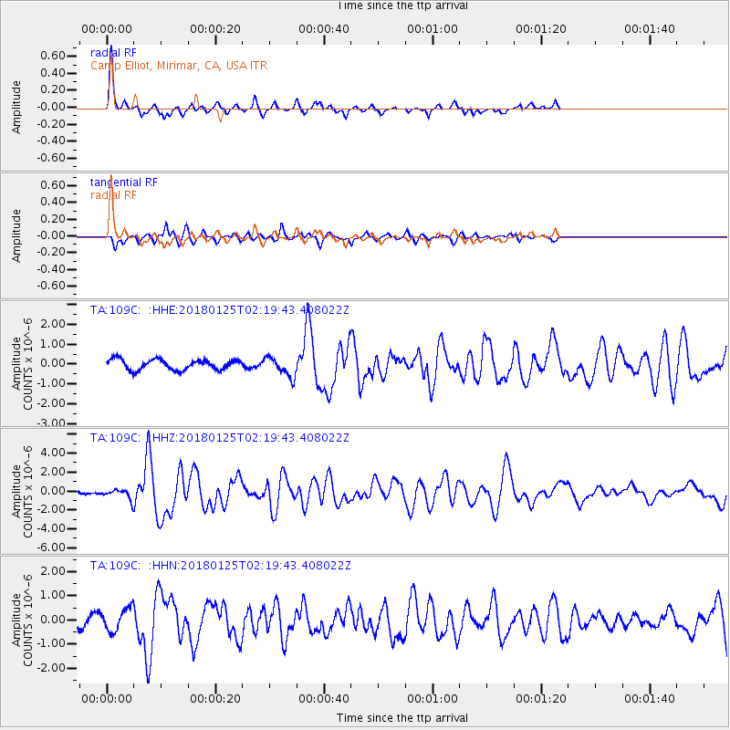
Signal To Noise
| Channel | StoN | STA | LTA |
| TA:109C: :HHZ:20180125T02:19:43.408022Z | 3.5345862 | 5.325769E-7 | 1.5067589E-7 |
| TA:109C: :HHN:20180125T02:19:43.408022Z | 2.1628659 | 4.694995E-7 | 2.1707287E-7 |
| TA:109C: :HHE:20180125T02:19:43.408022Z | 1.4070662 | 3.6856628E-7 | 2.6193953E-7 |
| Arrivals |
| Ps | 2.3 SECOND |
| PpPs | 7.7 SECOND |
| PsPs/PpSs | 10.0 SECOND |


