You are here: Home > Network List > TA - USArray Transportable Network (new EarthScope stations) Stations List
> Station M31M Drury Creek, Yukon, CA > Earthquake Result Viewer
M31M Drury Creek, Yukon, CA - Earthquake Result Viewer
| Earthquake location: |
Komandorskiye Ostrova Region |
| Earthquake latitude/longitude: |
55.4/166.5 |
| Earthquake time(UTC): |
2018/01/25 (025) 02:10:33 GMT |
| Earthquake Depth: |
8.8 km |
| Earthquake Magnitude: |
6.2 Mww |
| Earthquake Catalog/Contributor: |
NEIC PDE/us |
|
| Network: |
TA USArray Transportable Network (new EarthScope stations) |
| Station: |
M31M Drury Creek, Yukon, CA |
| Lat/Lon: |
62.20 N/134.39 W |
| Elevation: |
639 m |
|
| Distance: |
30.4 deg |
| Az: |
52.726 deg |
| Baz: |
284.495 deg |
| Ray Param: |
0.07934954 |
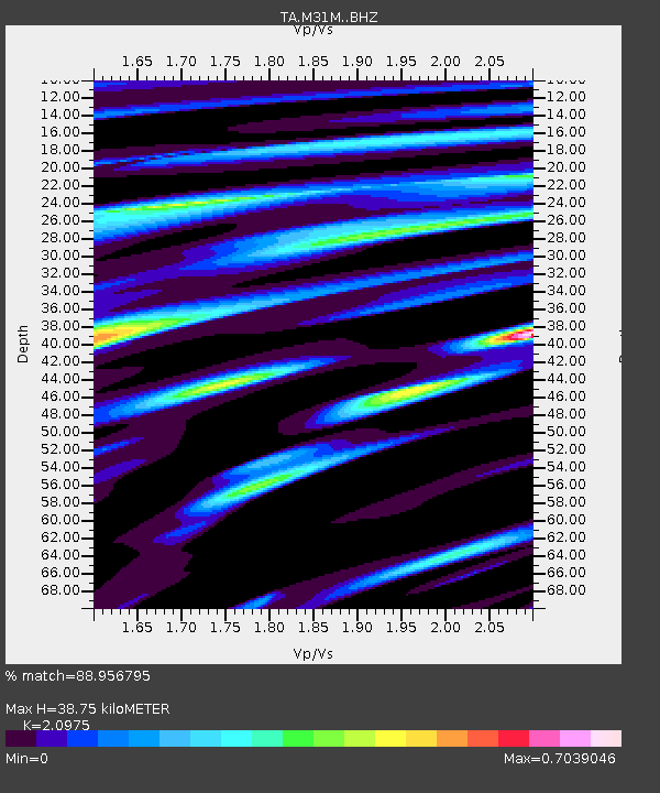
| Estimated Moho Depth: |
38.75 km |
| Estimated Crust Vp/Vs: |
2.10 |
| Assumed Crust Vp: |
6.419 km/s |
| Estimated Crust Vs: |
3.06 km/s |
| Estimated Crust Poisson's Ratio: |
0.35 |
|
| Radial Match: |
88.956795 % |
| Radial Bump: |
384 |
| Transverse Match: |
61.817463 % |
| Transverse Bump: |
400 |
| SOD ConfigId: |
13570011 |
| Insert Time: |
2019-04-29 15:57:58.758 +0000 |
| GWidth: |
2.5 |
| Max Bumps: |
400 |
| Tol: |
0.001 |
|

Signal To Noise
| Channel | StoN | STA | LTA |
| TA:M31M: :BHZ:20180125T02:16:15.399996Z | 8.6419 | 2.2568227E-6 | 2.611489E-7 |
| TA:M31M: :BHN:20180125T02:16:15.399996Z | 0.731825 | 2.6791392E-7 | 3.6609018E-7 |
| TA:M31M: :BHE:20180125T02:16:15.399996Z | 5.750081 | 1.4793492E-6 | 2.5727448E-7 |
| Arrivals |
| Ps | 7.1 SECOND |
| PpPs | 17 SECOND |
| PsPs/PpSs | 25 SECOND |


