You are here: Home > Network List > TA - USArray Transportable Network (new EarthScope stations) Stations List
> Station MSTX Muleshoe, TX, USA > Earthquake Result Viewer
MSTX Muleshoe, TX, USA - Earthquake Result Viewer
| Earthquake location: |
Komandorskiye Ostrova Region |
| Earthquake latitude/longitude: |
55.4/166.5 |
| Earthquake time(UTC): |
2018/01/25 (025) 02:10:33 GMT |
| Earthquake Depth: |
8.8 km |
| Earthquake Magnitude: |
6.2 Mww |
| Earthquake Catalog/Contributor: |
NEIC PDE/us |
|
| Network: |
TA USArray Transportable Network (new EarthScope stations) |
| Station: |
MSTX Muleshoe, TX, USA |
| Lat/Lon: |
33.97 N/102.77 W |
| Elevation: |
1167 m |
|
| Distance: |
63.2 deg |
| Az: |
68.57 deg |
| Baz: |
320.292 deg |
| Ray Param: |
0.05972301 |
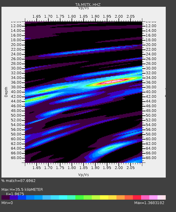
| Estimated Moho Depth: |
35.5 km |
| Estimated Crust Vp/Vs: |
1.97 |
| Assumed Crust Vp: |
6.129 km/s |
| Estimated Crust Vs: |
3.115 km/s |
| Estimated Crust Poisson's Ratio: |
0.33 |
|
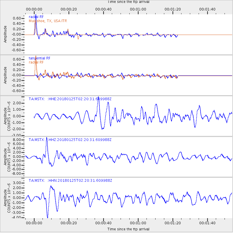
| Radial Match: |
87.6962 % |
| Radial Bump: |
299 |
| Transverse Match: |
66.27337 % |
| Transverse Bump: |
400 |
| SOD ConfigId: |
13570011 |
| Insert Time: |
2019-04-29 15:58:00.103 +0000 |
| GWidth: |
2.5 |
| Max Bumps: |
400 |
| Tol: |
0.001 |
|
Signal To Noise
| Channel | StoN | STA | LTA |
| TA:MSTX: :HHZ:20180125T02:20:31.609988Z | 4.663526 | 9.84661E-7 | 2.111409E-7 |
| TA:MSTX: :HHN:20180125T02:20:31.609988Z | 1.3090516 | 3.6938735E-7 | 2.8217937E-7 |
| TA:MSTX: :HHE:20180125T02:20:31.609988Z | 2.2181168 | 6.23888E-7 | 2.8126925E-7 |
| Arrivals |
| Ps | 5.8 SECOND |
| PpPs | 17 SECOND |
| PsPs/PpSs | 22 SECOND |


