You are here: Home > Network List > TA - USArray Transportable Network (new EarthScope stations) Stations List
> Station O23A Lake Granby, Granby, CO, USA > Earthquake Result Viewer
O23A Lake Granby, Granby, CO, USA - Earthquake Result Viewer

| Earthquake location: |
Tonga Islands |
| Earthquake latitude/longitude: |
-16.3/-173.5 |
| Earthquake time(UTC): |
2009/10/02 (275) 01:07:39 GMT |
| Earthquake Depth: |
8.0 km |
| Earthquake Magnitude: |
6.1 MB, 6.0 MS, 6.1 MW, 6.1 MW |
| Earthquake Catalog/Contributor: |
WHDF/NEIC |
|
| Network: |
TA USArray Transportable Network (new EarthScope stations) |
| Station: |
O23A Lake Granby, Granby, CO, USA |
| Lat/Lon: |
40.21 N/105.92 W |
| Elevation: |
2635 m |
|
| Distance: |
84.2 deg |
| Az: |
45.351 deg |
| Baz: |
243.12 deg |
| Ray Param: |
0.045652054 |
| Estimated Moho Depth: |
12.75 km |
| Estimated Crust Vp/Vs: |
2.10 |
| Assumed Crust Vp: |
6.306 km/s |
| Estimated Crust Vs: |
3.006 km/s |
| Estimated Crust Poisson's Ratio: |
0.35 |
|
| Radial Match: |
81.73663 % |
| Radial Bump: |
400 |
| Transverse Match: |
81.29506 % |
| Transverse Bump: |
400 |
| SOD ConfigId: |
2622 |
| Insert Time: |
2010-03-06 08:25:31.352 +0000 |
| GWidth: |
2.5 |
| Max Bumps: |
400 |
| Tol: |
0.001 |
|
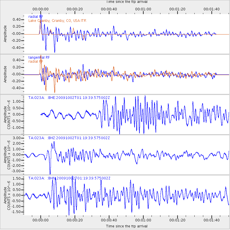
Signal To Noise
| Channel | StoN | STA | LTA |
| TA:O23A: :BHZ:20091002T01:19:39.575002Z | 3.143096 | 4.152863E-7 | 1.3212652E-7 |
| TA:O23A: :BHN:20091002T01:19:39.575002Z | 0.8474115 | 1.3362722E-7 | 1.5768869E-7 |
| TA:O23A: :BHE:20091002T01:19:39.575002Z | 0.93912476 | 1.5841744E-7 | 1.6868624E-7 |
| Arrivals |
| Ps | 2.3 SECOND |
| PpPs | 6.1 SECOND |
| PsPs/PpSs | 8.4 SECOND |


