You are here: Home > Network List > IW - Intermountain West Stations List
> Station MOOW Moose Ponds, Wyoming, USA > Earthquake Result Viewer
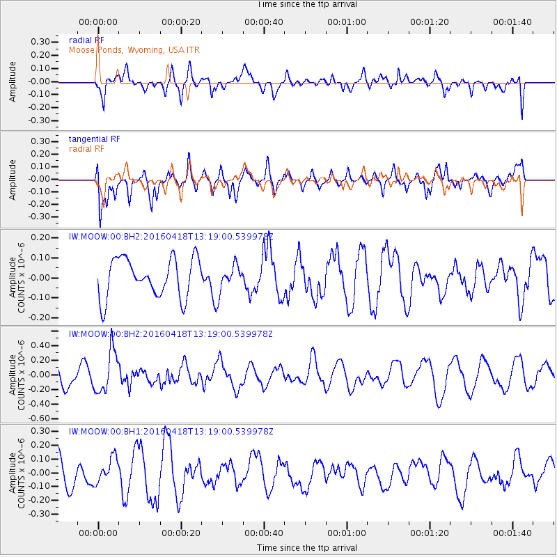
MOOW Moose Ponds, Wyoming, USA - Earthquake Result Viewer
*The percent match for this event was below the threshold and hence no stack was calculated.
| Earthquake location: |
Vanuatu Islands |
| Earthquake latitude/longitude: |
-19.5/169.0 |
| Earthquake time(UTC): |
2016/04/18 (109) 13:06:11 GMT |
| Earthquake Depth: |
74 km |
| Earthquake Magnitude: |
5.9 MO |
| Earthquake Catalog/Contributor: |
NEIC PDE/NEIC ALERT |
|
| Network: |
IW Intermountain West |
| Station: |
MOOW Moose Ponds, Wyoming, USA |
| Lat/Lon: |
43.75 N/110.74 W |
| Elevation: |
2128 m |
|
| Distance: |
96.4 deg |
| Az: |
45.948 deg |
| Baz: |
249.337 deg |
| Ray Param: |
$rayparam |
*The percent match for this event was below the threshold and hence was not used in the summary stack. |
|
| Radial Match: |
42.25799 % |
| Radial Bump: |
400 |
| Transverse Match: |
53.91902 % |
| Transverse Bump: |
400 |
| SOD ConfigId: |
1475611 |
| Insert Time: |
2016-05-02 13:09:36.892 +0000 |
| GWidth: |
2.5 |
| Max Bumps: |
400 |
| Tol: |
0.001 |
|
Signal To Noise
| Channel | StoN | STA | LTA |
| IW:MOOW:00:BHZ:20160418T13:19:00.539978Z | 2.8196578 | 2.9489053E-7 | 1.045838E-7 |
| IW:MOOW:00:BH1:20160418T13:19:00.539978Z | 0.6898257 | 9.456304E-8 | 1.3708251E-7 |
| IW:MOOW:00:BH2:20160418T13:19:00.539978Z | 0.5822463 | 5.7245675E-8 | 9.831865E-8 |
| Arrivals |
| Ps | |
| PpPs | |
| PsPs/PpSs | |


