You are here: Home > Network List > TA - USArray Transportable Network (new EarthScope stations) Stations List
> Station 121A Cookes Peak, Deming, NM, USA > Earthquake Result Viewer
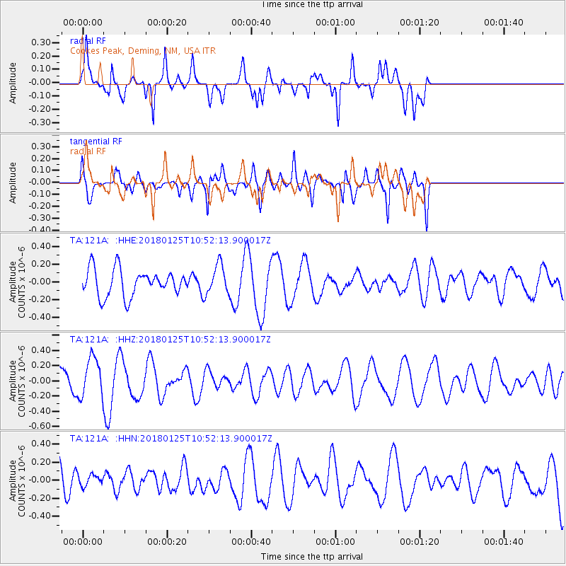
121A Cookes Peak, Deming, NM, USA - Earthquake Result Viewer
*The percent match for this event was below the threshold and hence no stack was calculated.
| Earthquake location: |
Fiji Islands Region |
| Earthquake latitude/longitude: |
-17.8/-179.6 |
| Earthquake time(UTC): |
2018/01/25 (025) 10:41:14 GMT |
| Earthquake Depth: |
621 km |
| Earthquake Magnitude: |
5.7 Mww |
| Earthquake Catalog/Contributor: |
NEIC PDE/us |
|
| Network: |
TA USArray Transportable Network (new EarthScope stations) |
| Station: |
121A Cookes Peak, Deming, NM, USA |
| Lat/Lon: |
32.53 N/107.79 W |
| Elevation: |
1652 m |
|
| Distance: |
84.9 deg |
| Az: |
53.696 deg |
| Baz: |
245.388 deg |
| Ray Param: |
$rayparam |
*The percent match for this event was below the threshold and hence was not used in the summary stack. |
|
| Radial Match: |
44.004204 % |
| Radial Bump: |
400 |
| Transverse Match: |
49.67896 % |
| Transverse Bump: |
400 |
| SOD ConfigId: |
13570011 |
| Insert Time: |
2019-04-29 16:04:34.658 +0000 |
| GWidth: |
2.5 |
| Max Bumps: |
400 |
| Tol: |
0.001 |
|
Signal To Noise
| Channel | StoN | STA | LTA |
| TA:121A: :HHZ:20180125T10:52:13.900017Z | 1.664204 | 2.6329073E-7 | 1.5820822E-7 |
| TA:121A: :HHN:20180125T10:52:13.900017Z | 0.37684017 | 6.486577E-8 | 1.7213073E-7 |
| TA:121A: :HHE:20180125T10:52:13.900017Z | 1.1124846 | 1.6827255E-7 | 1.5125833E-7 |
| Arrivals |
| Ps | |
| PpPs | |
| PsPs/PpSs | |


