You are here: Home > Network List > TA - USArray Transportable Network (new EarthScope stations) Stations List
> Station I30M Mount Dempster, Yukon, CAN > Earthquake Result Viewer
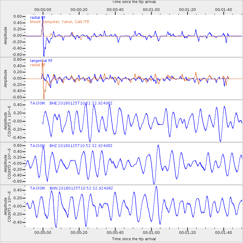
I30M Mount Dempster, Yukon, CAN - Earthquake Result Viewer
*The percent match for this event was below the threshold and hence no stack was calculated.
| Earthquake location: |
Fiji Islands Region |
| Earthquake latitude/longitude: |
-17.8/-179.6 |
| Earthquake time(UTC): |
2018/01/25 (025) 10:41:14 GMT |
| Earthquake Depth: |
621 km |
| Earthquake Magnitude: |
5.7 Mww |
| Earthquake Catalog/Contributor: |
NEIC PDE/us |
|
| Network: |
TA USArray Transportable Network (new EarthScope stations) |
| Station: |
I30M Mount Dempster, Yukon, CAN |
| Lat/Lon: |
65.22 N/136.38 W |
| Elevation: |
1399 m |
|
| Distance: |
89.0 deg |
| Az: |
16.792 deg |
| Baz: |
220.788 deg |
| Ray Param: |
$rayparam |
*The percent match for this event was below the threshold and hence was not used in the summary stack. |
|
| Radial Match: |
64.90898 % |
| Radial Bump: |
400 |
| Transverse Match: |
29.964624 % |
| Transverse Bump: |
400 |
| SOD ConfigId: |
13570011 |
| Insert Time: |
2019-04-29 16:04:49.157 +0000 |
| GWidth: |
2.5 |
| Max Bumps: |
400 |
| Tol: |
0.001 |
|
Signal To Noise
| Channel | StoN | STA | LTA |
| TA:I30M: :BHZ:20180125T10:52:32.92498Z | 3.2276278 | 3.6711378E-7 | 1.1374106E-7 |
| TA:I30M: :BHN:20180125T10:52:32.92498Z | 1.4849181 | 2.2508178E-7 | 1.5157858E-7 |
| TA:I30M: :BHE:20180125T10:52:32.92498Z | 0.81404734 | 1.5664905E-7 | 1.9243237E-7 |
| Arrivals |
| Ps | |
| PpPs | |
| PsPs/PpSs | |


