You are here: Home > Network List > TA - USArray Transportable Network (new EarthScope stations) Stations List
> Station O23A Lake Granby, Granby, CO, USA > Earthquake Result Viewer
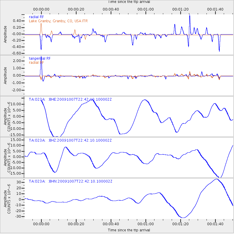
O23A Lake Granby, Granby, CO, USA - Earthquake Result Viewer
*The percent match for this event was below the threshold and hence no stack was calculated.
| Earthquake location: |
Santa Cruz Islands |
| Earthquake latitude/longitude: |
-11.5/166.0 |
| Earthquake time(UTC): |
2009/10/07 (280) 22:29:18 GMT |
| Earthquake Depth: |
35 km |
| Earthquake Magnitude: |
5.5 MB |
| Earthquake Catalog/Contributor: |
WHDF/NEIC |
|
| Network: |
TA USArray Transportable Network (new EarthScope stations) |
| Station: |
O23A Lake Granby, Granby, CO, USA |
| Lat/Lon: |
40.21 N/105.92 W |
| Elevation: |
2635 m |
|
| Distance: |
95.9 deg |
| Az: |
50.298 deg |
| Baz: |
259.973 deg |
| Ray Param: |
$rayparam |
*The percent match for this event was below the threshold and hence was not used in the summary stack. |
|
| Radial Match: |
63.568707 % |
| Radial Bump: |
223 |
| Transverse Match: |
67.12479 % |
| Transverse Bump: |
276 |
| SOD ConfigId: |
2622 |
| Insert Time: |
2010-03-06 08:26:44.616 +0000 |
| GWidth: |
2.5 |
| Max Bumps: |
400 |
| Tol: |
0.001 |
|
Signal To Noise
| Channel | StoN | STA | LTA |
| TA:O23A: :BHZ:20091007T22:42:10.100002Z | 1.144474 | 3.404081E-6 | 2.9743628E-6 |
| TA:O23A: :BHN:20091007T22:42:10.100002Z | 4.340229 | 6.6481857E-6 | 1.5317592E-6 |
| TA:O23A: :BHE:20091007T22:42:10.100002Z | 1.2913835 | 1.27751355E-5 | 9.892597E-6 |
| Arrivals |
| Ps | |
| PpPs | |
| PsPs/PpSs | |


