You are here: Home > Network List > IM - International Miscellaneous Stations Stations List
> Station MK31 Makanchi Array Site 31, Kazakhstan > Earthquake Result Viewer
MK31 Makanchi Array Site 31, Kazakhstan - Earthquake Result Viewer
| Earthquake location: |
Near N Coast Of New Guinea, P.N.G. |
| Earthquake latitude/longitude: |
-3.5/145.8 |
| Earthquake time(UTC): |
2018/01/26 (026) 22:47:57 GMT |
| Earthquake Depth: |
10 km |
| Earthquake Magnitude: |
6.3 Mww |
| Earthquake Catalog/Contributor: |
NEIC PDE/us |
|
| Network: |
IM International Miscellaneous Stations |
| Station: |
MK31 Makanchi Array Site 31, Kazakhstan |
| Lat/Lon: |
46.79 N/82.29 E |
| Elevation: |
618 m |
|
| Distance: |
74.9 deg |
| Az: |
320.409 deg |
| Baz: |
112.204 deg |
| Ray Param: |
0.052048728 |
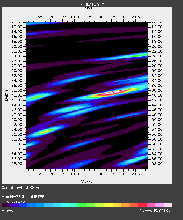
| Estimated Moho Depth: |
38.5 km |
| Estimated Crust Vp/Vs: |
1.96 |
| Assumed Crust Vp: |
6.688 km/s |
| Estimated Crust Vs: |
3.417 km/s |
| Estimated Crust Poisson's Ratio: |
0.32 |
|
| Radial Match: |
94.98806 % |
| Radial Bump: |
366 |
| Transverse Match: |
87.47608 % |
| Transverse Bump: |
400 |
| SOD ConfigId: |
13570011 |
| Insert Time: |
2019-04-29 16:13:00.836 +0000 |
| GWidth: |
2.5 |
| Max Bumps: |
400 |
| Tol: |
0.001 |
|

Signal To Noise
| Channel | StoN | STA | LTA |
| IM:MK31: :BHZ:20180126T22:59:07.12499Z | 11.28108 | 2.8604038E-8 | 2.5355762E-9 |
| IM:MK31: :BHN:20180126T22:59:07.12499Z | 1.5808358 | 5.1781566E-9 | 3.2755816E-9 |
| IM:MK31: :BHE:20180126T22:59:07.12499Z | 3.184005 | 9.043691E-9 | 2.8403506E-9 |
| Arrivals |
| Ps | 5.7 SECOND |
| PpPs | 16 SECOND |
| PsPs/PpSs | 22 SECOND |


