You are here: Home > Network List > MM - Myanmar National Seismic Network Stations List
> Station MDY Mandalay, Mandalay, Myanmar > Earthquake Result Viewer
MDY Mandalay, Mandalay, Myanmar - Earthquake Result Viewer
| Earthquake location: |
Near N Coast Of New Guinea, P.N.G. |
| Earthquake latitude/longitude: |
-3.5/145.8 |
| Earthquake time(UTC): |
2018/01/26 (026) 22:47:57 GMT |
| Earthquake Depth: |
10 km |
| Earthquake Magnitude: |
6.3 Mww |
| Earthquake Catalog/Contributor: |
NEIC PDE/us |
|
| Network: |
MM Myanmar National Seismic Network |
| Station: |
MDY Mandalay, Mandalay, Myanmar |
| Lat/Lon: |
22.02 N/96.11 E |
| Elevation: |
97 m |
|
| Distance: |
54.8 deg |
| Az: |
299.983 deg |
| Baz: |
111.299 deg |
| Ray Param: |
0.065195 |
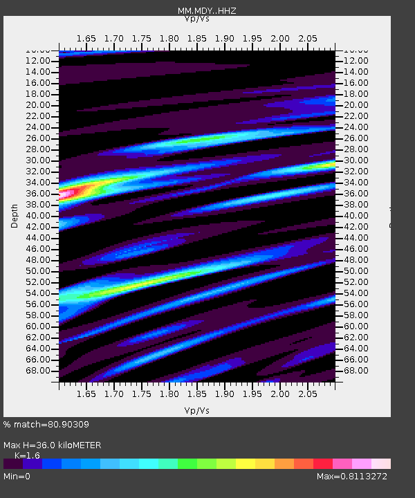
| Estimated Moho Depth: |
36.0 km |
| Estimated Crust Vp/Vs: |
1.60 |
| Assumed Crust Vp: |
6.316 km/s |
| Estimated Crust Vs: |
3.947 km/s |
| Estimated Crust Poisson's Ratio: |
0.18 |
|
| Radial Match: |
80.90309 % |
| Radial Bump: |
400 |
| Transverse Match: |
81.01596 % |
| Transverse Bump: |
400 |
| SOD ConfigId: |
13570011 |
| Insert Time: |
2019-04-29 16:13:33.450 +0000 |
| GWidth: |
2.5 |
| Max Bumps: |
400 |
| Tol: |
0.001 |
|

Signal To Noise
| Channel | StoN | STA | LTA |
| MM:MDY: :HHZ:20180126T22:56:56.937979Z | 5.2087398 | 5.704629E-7 | 1.0952032E-7 |
| MM:MDY: :HHN:20180126T22:56:56.937979Z | 2.263816 | 1.09316E-7 | 4.828837E-8 |
| MM:MDY: :HHE:20180126T22:56:56.937979Z | 6.976753 | 2.8993827E-7 | 4.155776E-8 |
| Arrivals |
| Ps | 3.6 SECOND |
| PpPs | 14 SECOND |
| PsPs/PpSs | 18 SECOND |


