You are here: Home > Network List > PS - Pacific21 Stations List
> Station PSI Parapat, Indonesia > Earthquake Result Viewer
PSI Parapat, Indonesia - Earthquake Result Viewer
| Earthquake location: |
Near N Coast Of New Guinea, P.N.G. |
| Earthquake latitude/longitude: |
-3.5/145.8 |
| Earthquake time(UTC): |
2018/01/26 (026) 22:47:57 GMT |
| Earthquake Depth: |
10 km |
| Earthquake Magnitude: |
6.3 Mww |
| Earthquake Catalog/Contributor: |
NEIC PDE/us |
|
| Network: |
PS Pacific21 |
| Station: |
PSI Parapat, Indonesia |
| Lat/Lon: |
2.69 N/98.92 E |
| Elevation: |
987 m |
|
| Distance: |
47.3 deg |
| Az: |
276.887 deg |
| Baz: |
97.241 deg |
| Ray Param: |
0.07007944 |
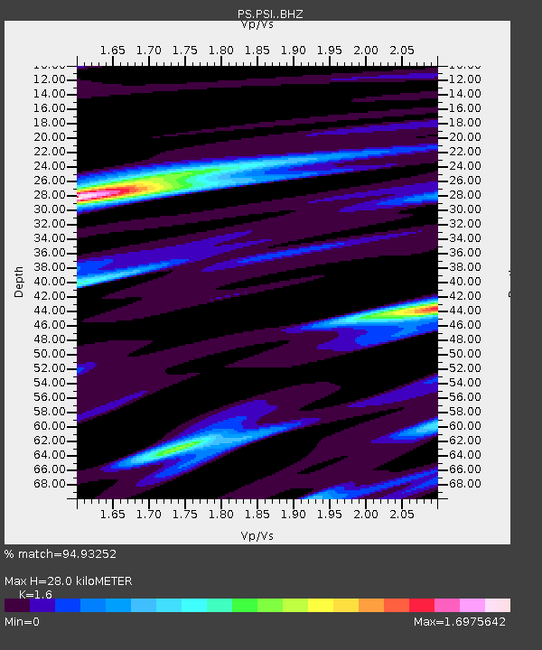
| Estimated Moho Depth: |
28.0 km |
| Estimated Crust Vp/Vs: |
1.60 |
| Assumed Crust Vp: |
6.468 km/s |
| Estimated Crust Vs: |
4.042 km/s |
| Estimated Crust Poisson's Ratio: |
0.18 |
|
| Radial Match: |
94.93252 % |
| Radial Bump: |
323 |
| Transverse Match: |
79.93471 % |
| Transverse Bump: |
365 |
| SOD ConfigId: |
13570011 |
| Insert Time: |
2019-04-29 16:13:57.100 +0000 |
| GWidth: |
2.5 |
| Max Bumps: |
400 |
| Tol: |
0.001 |
|
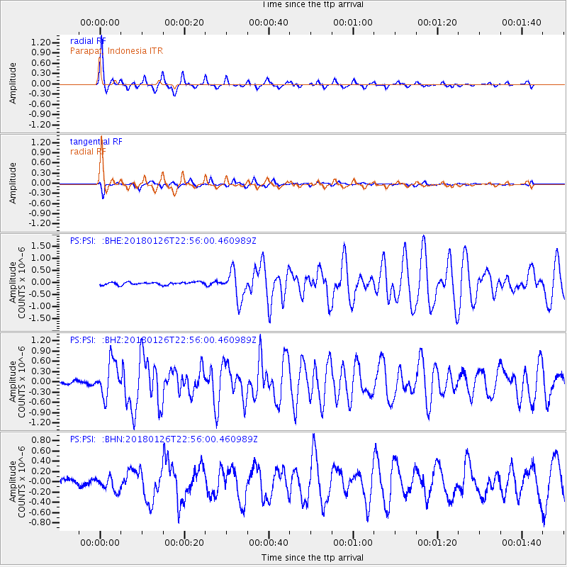
Signal To Noise
| Channel | StoN | STA | LTA |
| PS:PSI: :BHZ:20180126T22:56:00.460989Z | 15.169676 | 5.218374E-7 | 3.440004E-8 |
| PS:PSI: :BHN:20180126T22:56:00.460989Z | 1.8022988 | 1.4206866E-7 | 7.882636E-8 |
| PS:PSI: :BHE:20180126T22:56:00.460989Z | 10.926207 | 6.0710005E-7 | 5.5563664E-8 |
| Arrivals |
| Ps | 2.8 SECOND |
| PpPs | 11 SECOND |
| PsPs/PpSs | 13 SECOND |


