You are here: Home > Network List > TA - USArray Transportable Network (new EarthScope stations) Stations List
> Station A21K Barrow, AK, USA > Earthquake Result Viewer
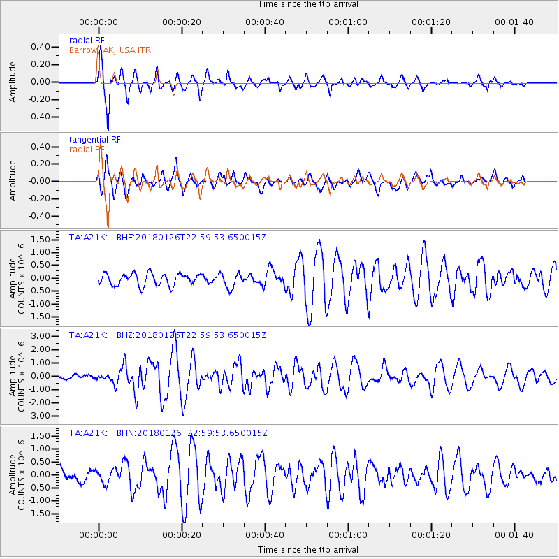
A21K Barrow, AK, USA - Earthquake Result Viewer
*The percent match for this event was below the threshold and hence no stack was calculated.
| Earthquake location: |
Near N Coast Of New Guinea, P.N.G. |
| Earthquake latitude/longitude: |
-3.5/145.8 |
| Earthquake time(UTC): |
2018/01/26 (026) 22:47:57 GMT |
| Earthquake Depth: |
10 km |
| Earthquake Magnitude: |
6.3 Mww |
| Earthquake Catalog/Contributor: |
NEIC PDE/us |
|
| Network: |
TA USArray Transportable Network (new EarthScope stations) |
| Station: |
A21K Barrow, AK, USA |
| Lat/Lon: |
71.32 N/156.62 W |
| Elevation: |
577 m |
|
| Distance: |
83.4 deg |
| Az: |
15.881 deg |
| Baz: |
237.971 deg |
| Ray Param: |
$rayparam |
*The percent match for this event was below the threshold and hence was not used in the summary stack. |
|
| Radial Match: |
92.935745 % |
| Radial Bump: |
379 |
| Transverse Match: |
84.648674 % |
| Transverse Bump: |
400 |
| SOD ConfigId: |
13570011 |
| Insert Time: |
2019-04-29 16:14:21.591 +0000 |
| GWidth: |
2.5 |
| Max Bumps: |
400 |
| Tol: |
0.001 |
|
Signal To Noise
| Channel | StoN | STA | LTA |
| TA:A21K: :BHZ:20180126T22:59:53.650015Z | 2.3906577 | 3.5318607E-7 | 1.4773595E-7 |
| TA:A21K: :BHN:20180126T22:59:53.650015Z | 1.4351383 | 2.5457445E-7 | 1.773867E-7 |
| TA:A21K: :BHE:20180126T22:59:53.650015Z | 1.2977289 | 2.928463E-7 | 2.2566063E-7 |
| Arrivals |
| Ps | |
| PpPs | |
| PsPs/PpSs | |


