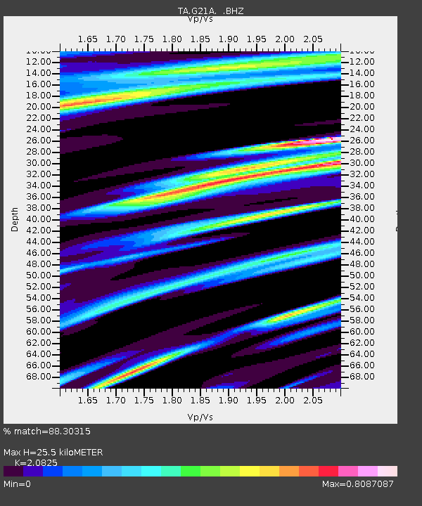
G21A Lodge Grass, MT, USA - Earthquake Result Viewer
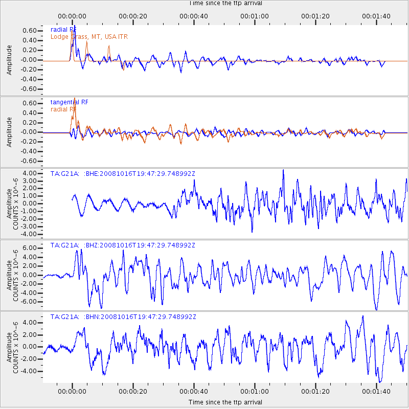
Earthquake location: Near Coast Of Chiapas, Mexico
Earthquake latitude/longitude: 14.4/-92.4
Earthquake time(UTC): 2008/10/16 (290) 19:41:25 GMT
Earthquake Depth: 24 km
Earthquake Magnitude: 6.1 MB, 6.6 MS, 6.7 MW, 6.6 MW
Earthquake Catalog/Contributor: WHDF/NEIC
Network: TA USArray Transportable Network (new EarthScope stations)
Station: G21A Lodge Grass, MT, USA
Lat/Lon: 45.22 N/107.21 W
Elevation: 1227 m
Distance: 33.2 deg
Az: 340.681 deg
Baz: 153.028 deg
Ray Param: 0.07829669
Estimated Moho Depth: 25.5 km
Estimated Crust Vp/Vs: 2.08
Assumed Crust Vp: 6.178 km/s
Estimated Crust Vs: 2.967 km/s
Estimated Crust Poisson's Ratio: 0.35
Radial Match: 88.30315 %
Radial Bump: 384
Transverse Match: 60.386635 %
Transverse Bump: 400
SOD ConfigId: 2556
Insert Time: 2010-03-06 08:27:58.501 +0000
GWidth: 2.5
Max Bumps: 400
Tol: 0.001

Signal To Noise

ChannelStoNSTALTA
TA:G21A: :BHZ:20081016T19:47:29.748992Z7.21742632.8138954E-63.8987517E-7
TA:G21A: :BHN:20081016T19:47:29.748992Z2.26072741.7550927E-67.7633985E-7
TA:G21A: :BHE:20081016T19:47:29.748992Z1.372998.864195E-76.456125E-7
Arrivals
Ps4.7 SECOND
PpPs12 SECOND
PsPs/PpSs17 SECOND