You are here: Home > Network List > US - United States National Seismic Network Stations List
> Station DUG Dugway, Tooele County, Utah, USA > Earthquake Result Viewer
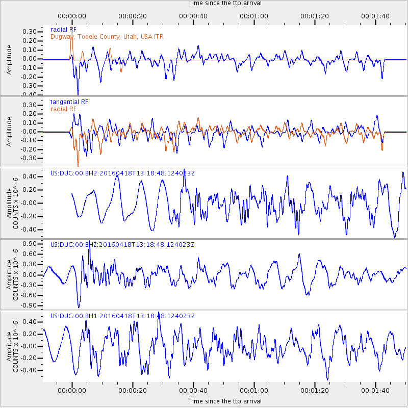
DUG Dugway, Tooele County, Utah, USA - Earthquake Result Viewer
*The percent match for this event was below the threshold and hence no stack was calculated.
| Earthquake location: |
Vanuatu Islands |
| Earthquake latitude/longitude: |
-19.5/169.0 |
| Earthquake time(UTC): |
2016/04/18 (109) 13:06:11 GMT |
| Earthquake Depth: |
74 km |
| Earthquake Magnitude: |
5.9 MO |
| Earthquake Catalog/Contributor: |
NEIC PDE/NEIC ALERT |
|
| Network: |
US United States National Seismic Network |
| Station: |
DUG Dugway, Tooele County, Utah, USA |
| Lat/Lon: |
40.19 N/112.81 W |
| Elevation: |
1477 m |
|
| Distance: |
93.7 deg |
| Az: |
48.698 deg |
| Baz: |
247.715 deg |
| Ray Param: |
$rayparam |
*The percent match for this event was below the threshold and hence was not used in the summary stack. |
|
| Radial Match: |
69.18812 % |
| Radial Bump: |
400 |
| Transverse Match: |
48.540302 % |
| Transverse Bump: |
400 |
| SOD ConfigId: |
1475611 |
| Insert Time: |
2016-05-02 13:11:47.446 +0000 |
| GWidth: |
2.5 |
| Max Bumps: |
400 |
| Tol: |
0.001 |
|
Signal To Noise
| Channel | StoN | STA | LTA |
| US:DUG:00:BHZ:20160418T13:18:48.124023Z | 1.5714028 | 4.2972266E-7 | 2.7346437E-7 |
| US:DUG:00:BH1:20160418T13:18:48.124023Z | 1.2497861 | 2.8281767E-7 | 2.2629284E-7 |
| US:DUG:00:BH2:20160418T13:18:48.124023Z | 1.2489275 | 2.4017228E-7 | 1.9230283E-7 |
| Arrivals |
| Ps | |
| PpPs | |
| PsPs/PpSs | |


