You are here: Home > Network List > TA - USArray Transportable Network (new EarthScope stations) Stations List
> Station G21A Lodge Grass, MT, USA > Earthquake Result Viewer
G21A Lodge Grass, MT, USA - Earthquake Result Viewer
| Earthquake location: |
Panama |
| Earthquake latitude/longitude: |
9.6/-79.0 |
| Earthquake time(UTC): |
2009/07/04 (185) 06:49:35 GMT |
| Earthquake Depth: |
38 km |
| Earthquake Magnitude: |
6.0 MB, 5.5 MS, 6.0 MW, 6.0 MW |
| Earthquake Catalog/Contributor: |
WHDF/NEIC |
|
| Network: |
TA USArray Transportable Network (new EarthScope stations) |
| Station: |
G21A Lodge Grass, MT, USA |
| Lat/Lon: |
45.22 N/107.21 W |
| Elevation: |
1227 m |
|
| Distance: |
43.0 deg |
| Az: |
330.651 deg |
| Baz: |
136.845 deg |
| Ray Param: |
0.07273342 |
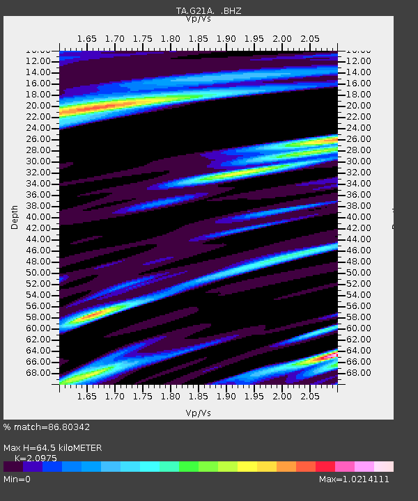
| Estimated Moho Depth: |
64.5 km |
| Estimated Crust Vp/Vs: |
2.10 |
| Assumed Crust Vp: |
6.178 km/s |
| Estimated Crust Vs: |
2.946 km/s |
| Estimated Crust Poisson's Ratio: |
0.35 |
|
| Radial Match: |
86.80342 % |
| Radial Bump: |
400 |
| Transverse Match: |
77.616714 % |
| Transverse Bump: |
400 |
| SOD ConfigId: |
2648 |
| Insert Time: |
2010-03-06 08:28:39.721 +0000 |
| GWidth: |
2.5 |
| Max Bumps: |
400 |
| Tol: |
0.001 |
|
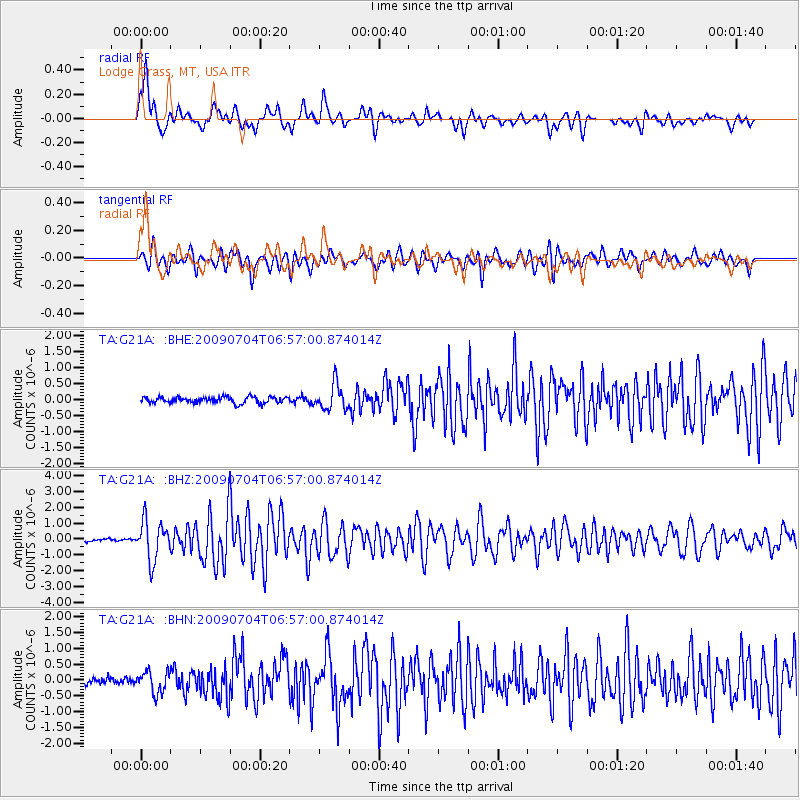
Signal To Noise
| Channel | StoN | STA | LTA |
| TA:G21A: :BHZ:20090704T06:57:00.874014Z | 13.481646 | 1.2382518E-6 | 9.184723E-8 |
| TA:G21A: :BHN:20090704T06:57:00.874014Z | 3.1952832 | 3.3739278E-7 | 1.0559089E-7 |
| TA:G21A: :BHE:20090704T06:57:00.874014Z | 4.217285 | 3.9711716E-7 | 9.416417E-8 |
| Arrivals |
| Ps | 12 SECOND |
| PpPs | 31 SECOND |
| PsPs/PpSs | 43 SECOND |


