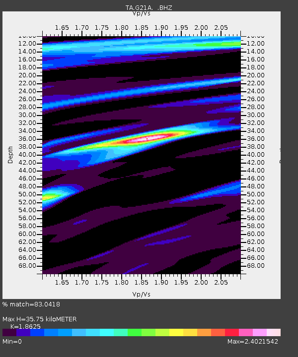
G21A Lodge Grass, MT, USA - Earthquake Result Viewer
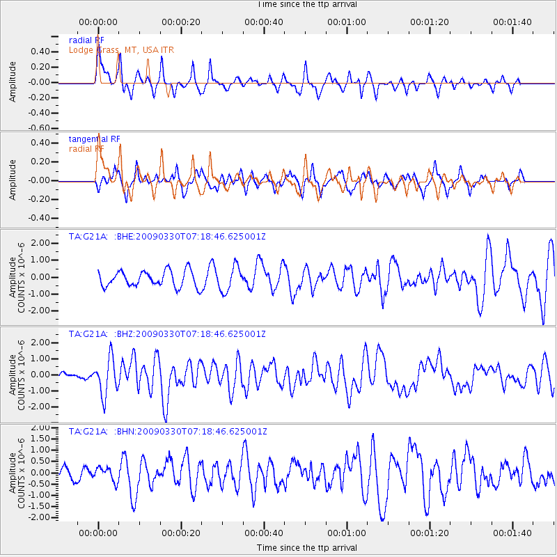
Earthquake location: Kodiak Island Region, Alaska
Earthquake latitude/longitude: 56.5/-152.7
Earthquake time(UTC): 2009/03/30 (089) 07:13:07 GMT
Earthquake Depth: 21 km
Earthquake Magnitude: 5.9 MB, 5.9 MS, 5.9 MW, 5.9 MW
Earthquake Catalog/Contributor: WHDF/NEIC
Network: TA USArray Transportable Network (new EarthScope stations)
Station: G21A Lodge Grass, MT, USA
Lat/Lon: 45.22 N/107.21 W
Elevation: 1227 m
Distance: 30.3 deg
Az: 92.306 deg
Baz: 308.458 deg
Ray Param: 0.079350226
Estimated Moho Depth: 35.75 km
Estimated Crust Vp/Vs: 1.86
Assumed Crust Vp: 6.178 km/s
Estimated Crust Vs: 3.317 km/s
Estimated Crust Poisson's Ratio: 0.30
Radial Match: 83.0418 %
Radial Bump: 400
Transverse Match: 63.465176 %
Transverse Bump: 400
SOD ConfigId: 2658
Insert Time: 2010-03-06 08:28:42.224 +0000
GWidth: 2.5
Max Bumps: 400
Tol: 0.001

Signal To Noise

ChannelStoNSTALTA
TA:G21A: :BHZ:20090330T07:18:46.625001Z4.5981881.1798276E-62.565853E-7
TA:G21A: :BHN:20090330T07:18:46.625001Z0.877424543.1556743E-73.5965195E-7
TA:G21A: :BHE:20090330T07:18:46.625001Z1.60141727.497442E-74.6817541E-7
Arrivals
Ps5.4 SECOND
PpPs15 SECOND
PsPs/PpSs21 SECOND