You are here: Home > Network List > YT07 - POLENET Stations List
> Station THUR THUR > Earthquake Result Viewer
THUR THUR - Earthquake Result Viewer
| Earthquake location: |
Southwest Of Africa |
| Earthquake latitude/longitude: |
-53.1/9.7 |
| Earthquake time(UTC): |
2018/01/28 (028) 16:03:03 GMT |
| Earthquake Depth: |
10 km |
| Earthquake Magnitude: |
6.6 Mww |
| Earthquake Catalog/Contributor: |
NEIC PDE/us |
|
| Network: |
YT POLENET |
| Station: |
THUR THUR |
| Lat/Lon: |
72.53 S/97.56 W |
| Elevation: |
239 m |
|
| Distance: |
45.1 deg |
| Az: |
204.039 deg |
| Baz: |
125.516 deg |
| Ray Param: |
0.071511485 |
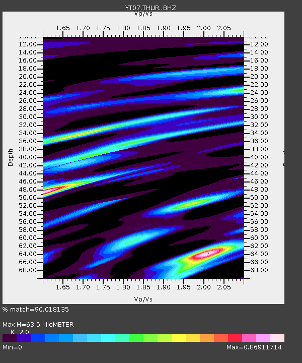
| Estimated Moho Depth: |
63.5 km |
| Estimated Crust Vp/Vs: |
2.01 |
| Assumed Crust Vp: |
6.43 km/s |
| Estimated Crust Vs: |
3.199 km/s |
| Estimated Crust Poisson's Ratio: |
0.34 |
|
| Radial Match: |
90.018135 % |
| Radial Bump: |
382 |
| Transverse Match: |
74.684166 % |
| Transverse Bump: |
400 |
| SOD ConfigId: |
13570011 |
| Insert Time: |
2019-04-29 16:25:39.632 +0000 |
| GWidth: |
2.5 |
| Max Bumps: |
400 |
| Tol: |
0.001 |
|

Signal To Noise
| Channel | StoN | STA | LTA |
| YT:THUR: :BHZ:20180128T16:10:49.200011Z | 6.5486326 | 1.0837138E-6 | 1.6548704E-7 |
| YT:THUR: :BHN:20180128T16:10:49.200011Z | 3.963464 | 6.000004E-7 | 1.5138284E-7 |
| YT:THUR: :BHE:20180128T16:10:49.200011Z | 4.092874 | 6.254197E-7 | 1.5280698E-7 |
| Arrivals |
| Ps | 11 SECOND |
| PpPs | 28 SECOND |
| PsPs/PpSs | 39 SECOND |


