You are here: Home > Network List > TA - USArray Transportable Network (new EarthScope stations) Stations List
> Station G21A Lodge Grass, MT, USA > Earthquake Result Viewer
G21A Lodge Grass, MT, USA - Earthquake Result Viewer
*The percent match for this event was below the threshold and hence no stack was calculated.
| Earthquake location: |
Colombia |
| Earthquake latitude/longitude: |
4.8/-75.5 |
| Earthquake time(UTC): |
2008/09/13 (257) 09:32:01 GMT |
| Earthquake Depth: |
133 km |
| Earthquake Magnitude: |
5.9 MB, 5.7 MW, 5.7 MW |
| Earthquake Catalog/Contributor: |
WHDF/NEIC |
|
| Network: |
TA USArray Transportable Network (new EarthScope stations) |
| Station: |
G21A Lodge Grass, MT, USA |
| Lat/Lon: |
45.22 N/107.21 W |
| Elevation: |
1227 m |
|
| Distance: |
48.9 deg |
| Az: |
330.463 deg |
| Baz: |
135.958 deg |
| Ray Param: |
$rayparam |
*The percent match for this event was below the threshold and hence was not used in the summary stack. |
|
| Radial Match: |
57.17084 % |
| Radial Bump: |
400 |
| Transverse Match: |
61.320084 % |
| Transverse Bump: |
400 |
| SOD ConfigId: |
2560 |
| Insert Time: |
2010-03-06 08:28:56.055 +0000 |
| GWidth: |
2.5 |
| Max Bumps: |
400 |
| Tol: |
0.001 |
|
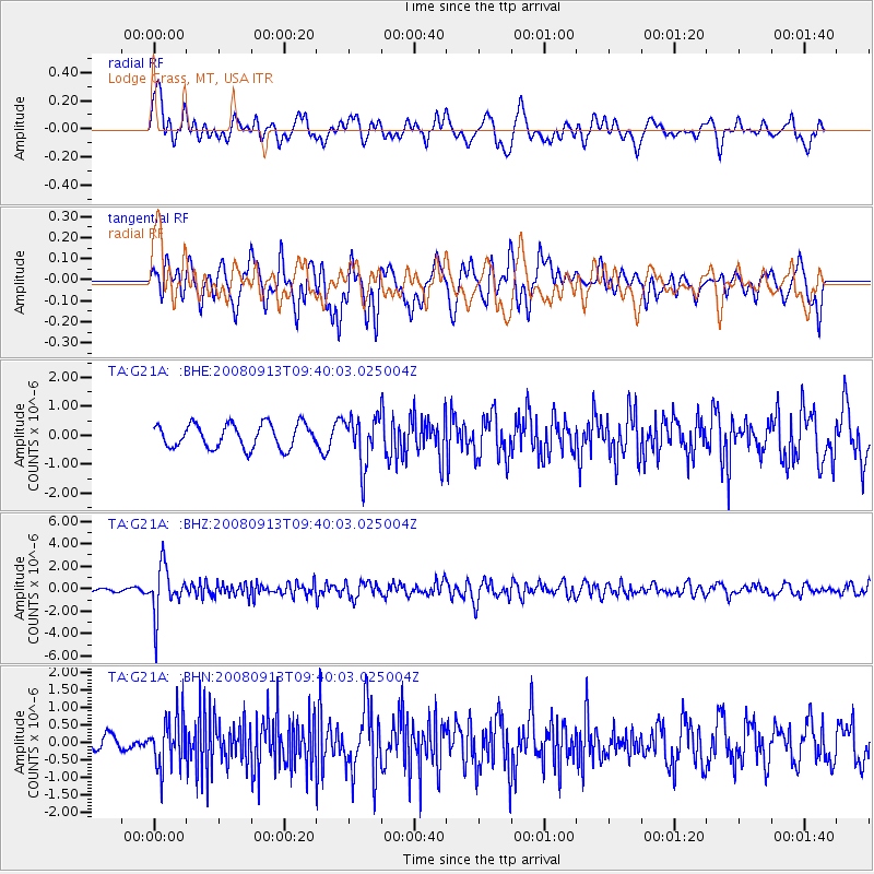
Signal To Noise
| Channel | StoN | STA | LTA |
| TA:G21A: :BHZ:20080913T09:40:03.025004Z | 13.025271 | 2.1092062E-6 | 1.6193184E-7 |
| TA:G21A: :BHN:20080913T09:40:03.025004Z | 3.2019572 | 7.16009E-7 | 2.2361604E-7 |
| TA:G21A: :BHE:20080913T09:40:03.025004Z | 2.016487 | 8.324298E-7 | 4.1281194E-7 |
| Arrivals |
| Ps | |
| PpPs | |
| PsPs/PpSs | |


