You are here: Home > Network List > TA - USArray Transportable Network (new EarthScope stations) Stations List
> Station G21A Lodge Grass, MT, USA > Earthquake Result Viewer
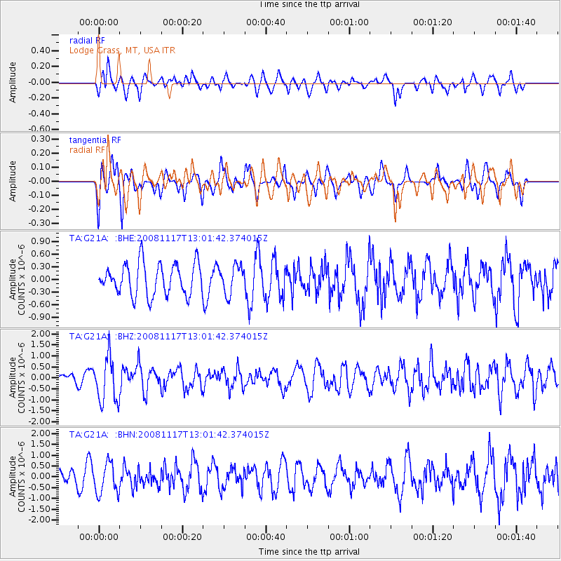
G21A Lodge Grass, MT, USA - Earthquake Result Viewer
*The percent match for this event was below the threshold and hence no stack was calculated.
| Earthquake location: |
Arctic Ocean |
| Earthquake latitude/longitude: |
79.6/-116.1 |
| Earthquake time(UTC): |
2008/11/17 (322) 12:55:22 GMT |
| Earthquake Depth: |
7.0 km |
| Earthquake Magnitude: |
5.7 MW, 5.2 MS, 5.4 MB, 5.7 MW |
| Earthquake Catalog/Contributor: |
WHDF/NEIC |
|
| Network: |
TA USArray Transportable Network (new EarthScope stations) |
| Station: |
G21A Lodge Grass, MT, USA |
| Lat/Lon: |
45.22 N/107.21 W |
| Elevation: |
1227 m |
|
| Distance: |
34.7 deg |
| Az: |
168.991 deg |
| Baz: |
357.199 deg |
| Ray Param: |
$rayparam |
*The percent match for this event was below the threshold and hence was not used in the summary stack. |
|
| Radial Match: |
56.667953 % |
| Radial Bump: |
400 |
| Transverse Match: |
50.407578 % |
| Transverse Bump: |
370 |
| SOD ConfigId: |
2658 |
| Insert Time: |
2010-03-06 08:29:03.845 +0000 |
| GWidth: |
2.5 |
| Max Bumps: |
400 |
| Tol: |
0.001 |
|
Signal To Noise
| Channel | StoN | STA | LTA |
| TA:G21A: :BHZ:20081117T13:01:42.374015Z | 2.4476905 | 1.0572265E-6 | 4.3192819E-7 |
| TA:G21A: :BHN:20081117T13:01:42.374015Z | 2.187998 | 7.420734E-7 | 3.3915632E-7 |
| TA:G21A: :BHE:20081117T13:01:42.374015Z | 0.89926046 | 3.3817102E-7 | 3.7605457E-7 |
| Arrivals |
| Ps | |
| PpPs | |
| PsPs/PpSs | |


