You are here: Home > Network List > TA - USArray Transportable Network (new EarthScope stations) Stations List
> Station G21A Lodge Grass, MT, USA > Earthquake Result Viewer
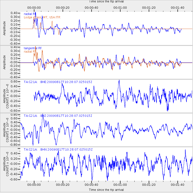
G21A Lodge Grass, MT, USA - Earthquake Result Viewer
*The percent match for this event was below the threshold and hence no stack was calculated.
| Earthquake location: |
Southwestern Ryukyu Isl., Japan |
| Earthquake latitude/longitude: |
23.4/123.7 |
| Earthquake time(UTC): |
2009/08/17 (229) 10:15:05 GMT |
| Earthquake Depth: |
10 km |
| Earthquake Magnitude: |
5.7 MB |
| Earthquake Catalog/Contributor: |
WHDF/NEIC |
|
| Network: |
TA USArray Transportable Network (new EarthScope stations) |
| Station: |
G21A Lodge Grass, MT, USA |
| Lat/Lon: |
45.22 N/107.21 W |
| Elevation: |
1227 m |
|
| Distance: |
97.4 deg |
| Az: |
33.59 deg |
| Baz: |
314.018 deg |
| Ray Param: |
$rayparam |
*The percent match for this event was below the threshold and hence was not used in the summary stack. |
|
| Radial Match: |
70.23778 % |
| Radial Bump: |
400 |
| Transverse Match: |
65.73175 % |
| Transverse Bump: |
400 |
| SOD ConfigId: |
2622 |
| Insert Time: |
2010-03-06 08:29:13.584 +0000 |
| GWidth: |
2.5 |
| Max Bumps: |
400 |
| Tol: |
0.001 |
|
Signal To Noise
| Channel | StoN | STA | LTA |
| TA:G21A: :BHZ:20090817T10:28:07.025015Z | 1.6572394 | 3.9362303E-7 | 2.3751728E-7 |
| TA:G21A: :BHN:20090817T10:28:07.025015Z | 0.83492833 | 1.5951207E-7 | 1.9104881E-7 |
| TA:G21A: :BHE:20090817T10:28:07.025015Z | 1.436514 | 2.2088061E-7 | 1.5376153E-7 |
| Arrivals |
| Ps | |
| PpPs | |
| PsPs/PpSs | |


