You are here: Home > Network List > TA - USArray Transportable Network (new EarthScope stations) Stations List
> Station G21A Lodge Grass, MT, USA > Earthquake Result Viewer
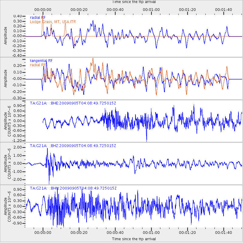
G21A Lodge Grass, MT, USA - Earthquake Result Viewer
*The percent match for this event was below the threshold and hence no stack was calculated.
| Earthquake location: |
Southern Peru |
| Earthquake latitude/longitude: |
-15.1/-70.2 |
| Earthquake time(UTC): |
2009/09/05 (248) 03:58:39 GMT |
| Earthquake Depth: |
210 km |
| Earthquake Magnitude: |
5.8 MW, 5.2 MB, 5.8 MW |
| Earthquake Catalog/Contributor: |
WHDF/NEIC |
|
| Network: |
TA USArray Transportable Network (new EarthScope stations) |
| Station: |
G21A Lodge Grass, MT, USA |
| Lat/Lon: |
45.22 N/107.21 W |
| Elevation: |
1227 m |
|
| Distance: |
68.8 deg |
| Az: |
332.883 deg |
| Baz: |
141.469 deg |
| Ray Param: |
$rayparam |
*The percent match for this event was below the threshold and hence was not used in the summary stack. |
|
| Radial Match: |
55.121326 % |
| Radial Bump: |
400 |
| Transverse Match: |
45.38103 % |
| Transverse Bump: |
400 |
| SOD ConfigId: |
2622 |
| Insert Time: |
2010-03-06 08:29:22.526 +0000 |
| GWidth: |
2.5 |
| Max Bumps: |
400 |
| Tol: |
0.001 |
|
Signal To Noise
| Channel | StoN | STA | LTA |
| TA:G21A: :BHZ:20090905T04:08:49.725015Z | 5.9375706 | 7.217936E-7 | 1.2156379E-7 |
| TA:G21A: :BHN:20090905T04:08:49.725015Z | 1.5624928 | 3.3914708E-7 | 2.1705512E-7 |
| TA:G21A: :BHE:20090905T04:08:49.725015Z | 1.2802738 | 2.3551969E-7 | 1.8396041E-7 |
| Arrivals |
| Ps | |
| PpPs | |
| PsPs/PpSs | |


