You are here: Home > Network List > TA - USArray Transportable Network (new EarthScope stations) Stations List
> Station G21A Lodge Grass, MT, USA > Earthquake Result Viewer
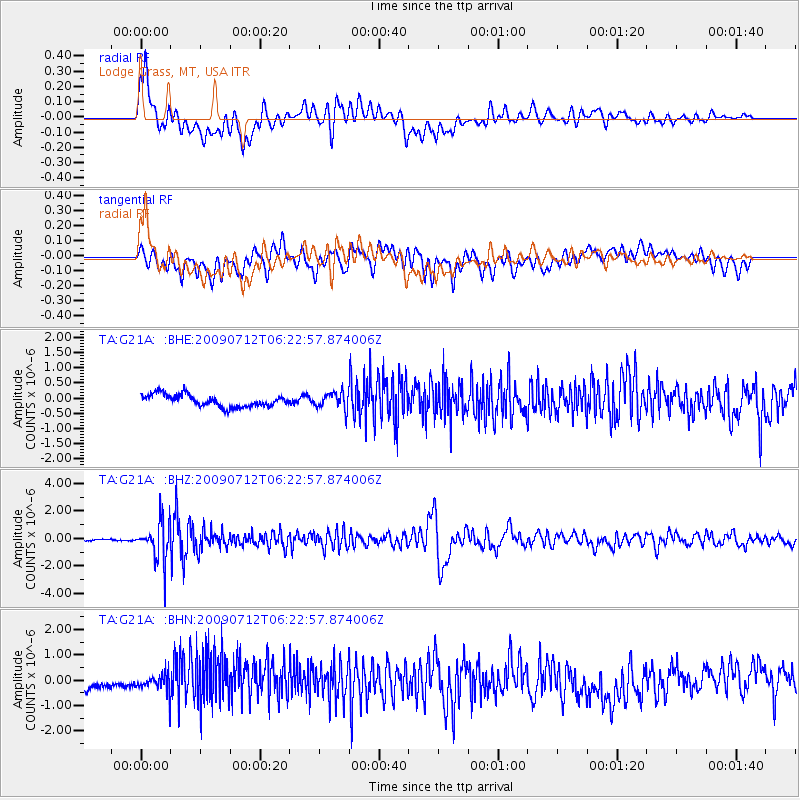
G21A Lodge Grass, MT, USA - Earthquake Result Viewer
*The percent match for this event was below the threshold and hence no stack was calculated.
| Earthquake location: |
Southern Peru |
| Earthquake latitude/longitude: |
-15.0/-70.4 |
| Earthquake time(UTC): |
2009/07/12 (193) 06:12:47 GMT |
| Earthquake Depth: |
199 km |
| Earthquake Magnitude: |
5.7 MB, 6.1 MW, 6.1 MW |
| Earthquake Catalog/Contributor: |
WHDF/NEIC |
|
| Network: |
TA USArray Transportable Network (new EarthScope stations) |
| Station: |
G21A Lodge Grass, MT, USA |
| Lat/Lon: |
45.22 N/107.21 W |
| Elevation: |
1227 m |
|
| Distance: |
68.6 deg |
| Az: |
332.986 deg |
| Baz: |
141.612 deg |
| Ray Param: |
$rayparam |
*The percent match for this event was below the threshold and hence was not used in the summary stack. |
|
| Radial Match: |
73.80704 % |
| Radial Bump: |
400 |
| Transverse Match: |
65.146065 % |
| Transverse Bump: |
400 |
| SOD ConfigId: |
2648 |
| Insert Time: |
2010-03-06 08:30:10.395 +0000 |
| GWidth: |
2.5 |
| Max Bumps: |
400 |
| Tol: |
0.001 |
|
Signal To Noise
| Channel | StoN | STA | LTA |
| TA:G21A: :BHZ:20090712T06:22:57.874006Z | 16.489405 | 1.446019E-6 | 8.7693834E-8 |
| TA:G21A: :BHN:20090712T06:22:57.874006Z | 2.0713632 | 3.9067743E-7 | 1.8860884E-7 |
| TA:G21A: :BHE:20090712T06:22:57.874006Z | 1.3811665 | 2.732395E-7 | 1.9783242E-7 |
| Arrivals |
| Ps | |
| PpPs | |
| PsPs/PpSs | |


