You are here: Home > Network List > TA - USArray Transportable Network (new EarthScope stations) Stations List
> Station MSTX Muleshoe, TX, USA > Earthquake Result Viewer
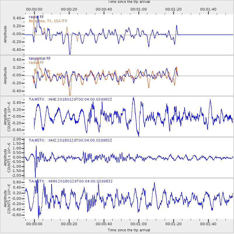
MSTX Muleshoe, TX, USA - Earthquake Result Viewer
*The percent match for this event was below the threshold and hence no stack was calculated.
| Earthquake location: |
San Juan Province, Argentina |
| Earthquake latitude/longitude: |
-31.3/-68.7 |
| Earthquake time(UTC): |
2018/01/28 (028) 23:53:14 GMT |
| Earthquake Depth: |
88 km |
| Earthquake Magnitude: |
5.4 Mww |
| Earthquake Catalog/Contributor: |
NEIC PDE/us |
|
| Network: |
TA USArray Transportable Network (new EarthScope stations) |
| Station: |
MSTX Muleshoe, TX, USA |
| Lat/Lon: |
33.97 N/102.77 W |
| Elevation: |
1167 m |
|
| Distance: |
72.4 deg |
| Az: |
330.741 deg |
| Baz: |
149.763 deg |
| Ray Param: |
$rayparam |
*The percent match for this event was below the threshold and hence was not used in the summary stack. |
|
| Radial Match: |
55.26145 % |
| Radial Bump: |
400 |
| Transverse Match: |
50.375046 % |
| Transverse Bump: |
400 |
| SOD ConfigId: |
13570011 |
| Insert Time: |
2019-04-29 16:36:03.245 +0000 |
| GWidth: |
2.5 |
| Max Bumps: |
400 |
| Tol: |
0.001 |
|
Signal To Noise
| Channel | StoN | STA | LTA |
| TA:MSTX: :HHZ:20180129T00:04:00.039983Z | 7.930798 | 6.4503183E-7 | 8.133253E-8 |
| TA:MSTX: :HHN:20180129T00:04:00.039983Z | 3.8806496 | 3.9902082E-7 | 1.028232E-7 |
| TA:MSTX: :HHE:20180129T00:04:00.039983Z | 1.469792 | 2.6218095E-7 | 1.7837962E-7 |
| Arrivals |
| Ps | |
| PpPs | |
| PsPs/PpSs | |


