You are here: Home > Network List > TA - USArray Transportable Network (new EarthScope stations) Stations List
> Station G21A Lodge Grass, MT, USA > Earthquake Result Viewer
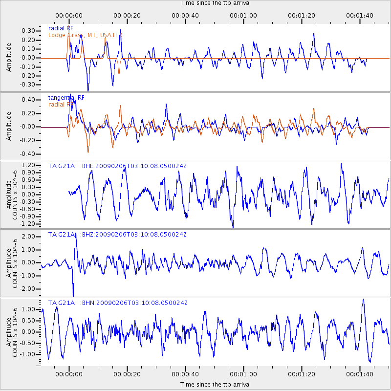
G21A Lodge Grass, MT, USA - Earthquake Result Viewer
*The percent match for this event was below the threshold and hence no stack was calculated.
| Earthquake location: |
Near Coast Of Northern Chile |
| Earthquake latitude/longitude: |
-28.0/-71.1 |
| Earthquake time(UTC): |
2009/02/06 (037) 02:58:35 GMT |
| Earthquake Depth: |
52 km |
| Earthquake Magnitude: |
5.5 MB |
| Earthquake Catalog/Contributor: |
WHDF/NEIC |
|
| Network: |
TA USArray Transportable Network (new EarthScope stations) |
| Station: |
G21A Lodge Grass, MT, USA |
| Lat/Lon: |
45.22 N/107.21 W |
| Elevation: |
1227 m |
|
| Distance: |
79.9 deg |
| Az: |
334.981 deg |
| Baz: |
148.046 deg |
| Ray Param: |
$rayparam |
*The percent match for this event was below the threshold and hence was not used in the summary stack. |
|
| Radial Match: |
54.045734 % |
| Radial Bump: |
400 |
| Transverse Match: |
51.283333 % |
| Transverse Bump: |
400 |
| SOD ConfigId: |
2658 |
| Insert Time: |
2010-03-06 08:30:25.238 +0000 |
| GWidth: |
2.5 |
| Max Bumps: |
400 |
| Tol: |
0.001 |
|
Signal To Noise
| Channel | StoN | STA | LTA |
| TA:G21A: :BHZ:20090206T03:10:08.050024Z | 2.7415133 | 9.4179063E-7 | 3.435295E-7 |
| TA:G21A: :BHN:20090206T03:10:08.050024Z | 0.83366674 | 4.211117E-7 | 5.0513194E-7 |
| TA:G21A: :BHE:20090206T03:10:08.050024Z | 0.80074245 | 4.4510676E-7 | 5.558676E-7 |
| Arrivals |
| Ps | |
| PpPs | |
| PsPs/PpSs | |


