You are here: Home > Network List > TA - USArray Transportable Network (new EarthScope stations) Stations List
> Station G20A Bridger, MT, USA > Earthquake Result Viewer
G20A Bridger, MT, USA - Earthquake Result Viewer
| Earthquake location: |
Central Mid-Atlantic Ridge |
| Earthquake latitude/longitude: |
8.1/-38.7 |
| Earthquake time(UTC): |
2008/09/10 (254) 13:08:14 GMT |
| Earthquake Depth: |
10 km |
| Earthquake Magnitude: |
6.3 MB, 6.5 MS, 6.6 MW, 6.6 MW |
| Earthquake Catalog/Contributor: |
WHDF/NEIC |
|
| Network: |
TA USArray Transportable Network (new EarthScope stations) |
| Station: |
G20A Bridger, MT, USA |
| Lat/Lon: |
45.22 N/108.21 W |
| Elevation: |
1431 m |
|
| Distance: |
69.9 deg |
| Az: |
315.168 deg |
| Baz: |
98.978 deg |
| Ray Param: |
0.055355765 |
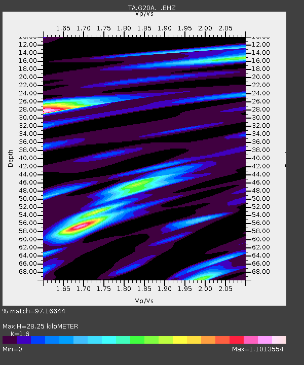
| Estimated Moho Depth: |
28.25 km |
| Estimated Crust Vp/Vs: |
1.60 |
| Assumed Crust Vp: |
6.242 km/s |
| Estimated Crust Vs: |
3.901 km/s |
| Estimated Crust Poisson's Ratio: |
0.18 |
|
| Radial Match: |
97.16644 % |
| Radial Bump: |
268 |
| Transverse Match: |
90.05723 % |
| Transverse Bump: |
400 |
| SOD ConfigId: |
2560 |
| Insert Time: |
2010-03-06 08:30:57.575 +0000 |
| GWidth: |
2.5 |
| Max Bumps: |
400 |
| Tol: |
0.001 |
|

Signal To Noise
| Channel | StoN | STA | LTA |
| TA:G20A: :BHZ:20080910T13:18:54.574001Z | 8.726113 | 1.2694047E-6 | 1.4547194E-7 |
| TA:G20A: :BHN:20080910T13:18:54.574001Z | 1.6520449 | 1.4541395E-7 | 8.8020585E-8 |
| TA:G20A: :BHE:20080910T13:18:54.574001Z | 3.9750488 | 4.779195E-7 | 1.2022984E-7 |
| Arrivals |
| Ps | 2.8 SECOND |
| PpPs | 11 SECOND |
| PsPs/PpSs | 14 SECOND |


