You are here: Home > Network List > WI - West Indies IPGP Network Stations List
> Station MPOM Morne Pois, Sainte-Anne, Martinique > Earthquake Result Viewer
MPOM Morne Pois, Sainte-Anne, Martinique - Earthquake Result Viewer
| Earthquake location: |
South Sandwich Islands Region |
| Earthquake latitude/longitude: |
-55.6/-27.2 |
| Earthquake time(UTC): |
2016/04/19 (110) 05:25:39 GMT |
| Earthquake Depth: |
11 km |
| Earthquake Magnitude: |
5.9 MB |
| Earthquake Catalog/Contributor: |
NEIC PDE/NEIC COMCAT |
|
| Network: |
WI West Indies IPGP Network |
| Station: |
MPOM Morne Pois, Sainte-Anne, Martinique |
| Lat/Lon: |
14.45 N/60.86 W |
| Elevation: |
50 m |
|
| Distance: |
75.3 deg |
| Az: |
326.318 deg |
| Baz: |
161.053 deg |
| Ray Param: |
0.05174474 |
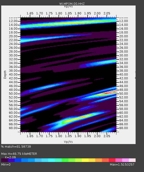
| Estimated Moho Depth: |
48.75 km |
| Estimated Crust Vp/Vs: |
2.09 |
| Assumed Crust Vp: |
5.88 km/s |
| Estimated Crust Vs: |
2.814 km/s |
| Estimated Crust Poisson's Ratio: |
0.35 |
|
| Radial Match: |
81.59739 % |
| Radial Bump: |
400 |
| Transverse Match: |
49.30671 % |
| Transverse Bump: |
400 |
| SOD ConfigId: |
1475611 |
| Insert Time: |
2016-05-03 05:30:06.900 +0000 |
| GWidth: |
2.5 |
| Max Bumps: |
400 |
| Tol: |
0.001 |
|

Signal To Noise
| Channel | StoN | STA | LTA |
| WI:MPOM:00:HHZ:20160419T05:36:51.509973Z | 3.7378905 | 8.6822183E-7 | 2.322759E-7 |
| WI:MPOM:00:HHN:20160419T05:36:51.509973Z | 1.4139556 | 3.5944797E-7 | 2.5421448E-7 |
| WI:MPOM:00:HHE:20160419T05:36:51.509973Z | 1.0707986 | 2.6926557E-7 | 2.5146235E-7 |
| Arrivals |
| Ps | 9.2 SECOND |
| PpPs | 25 SECOND |
| PsPs/PpSs | 34 SECOND |


