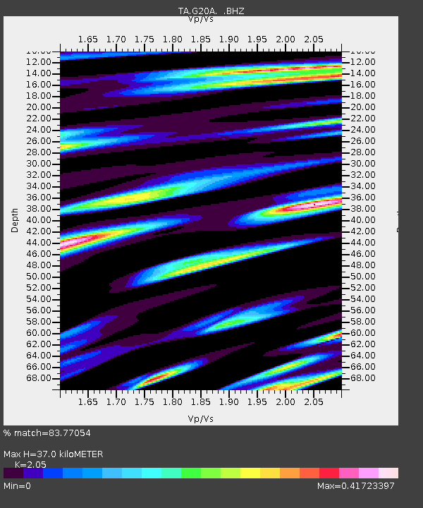
G20A Bridger, MT, USA - Earthquake Result Viewer

Earthquake location: Southwestern Ryukyu Isl., Japan
Earthquake latitude/longitude: 23.5/123.5
Earthquake time(UTC): 2009/08/17 (229) 00:05:49 GMT
Earthquake Depth: 20 km
Earthquake Magnitude: 6.2 MB, 6.6 MS, 6.7 MW, 6.6 MW
Earthquake Catalog/Contributor: WHDF/NEIC
Network: TA USArray Transportable Network (new EarthScope stations)
Station: G20A Bridger, MT, USA
Lat/Lon: 45.22 N/108.21 W
Elevation: 1431 m
Distance: 97.0 deg
Az: 33.979 deg
Baz: 313.452 deg
Ray Param: 0.040346235
Estimated Moho Depth: 37.0 km
Estimated Crust Vp/Vs: 2.05
Assumed Crust Vp: 6.242 km/s
Estimated Crust Vs: 3.045 km/s
Estimated Crust Poisson's Ratio: 0.34
Radial Match: 83.77054 %
Radial Bump: 400
Transverse Match: 67.173836 %
Transverse Bump: 400
SOD ConfigId: 2622
Insert Time: 2010-03-06 08:31:27.449 +0000
GWidth: 2.5
Max Bumps: 400
Tol: 0.001

Signal To Noise

ChannelStoNSTALTA
TA:G20A: :BHZ:20090817T00:18:47.399019Z4.72455172.9240925E-76.189143E-8
TA:G20A: :BHN:20090817T00:18:47.399019Z1.67346065.6878118E-83.398832E-8
TA:G20A: :BHE:20090817T00:18:47.399019Z2.2530756.957261E-83.0878958E-8
Arrivals
Ps6.3 SECOND
PpPs18 SECOND
PsPs/PpSs24 SECOND