You are here: Home > Network List > TA - USArray Transportable Network (new EarthScope stations) Stations List
> Station G20A Bridger, MT, USA > Earthquake Result Viewer
G20A Bridger, MT, USA - Earthquake Result Viewer
| Earthquake location: |
Near Coast Of Venezuela |
| Earthquake latitude/longitude: |
10.7/-67.9 |
| Earthquake time(UTC): |
2009/09/12 (255) 20:06:24 GMT |
| Earthquake Depth: |
10 km |
| Earthquake Magnitude: |
6.3 MB, 6.4 MS, 6.3 MW, 6.3 MW |
| Earthquake Catalog/Contributor: |
WHDF/NEIC |
|
| Network: |
TA USArray Transportable Network (new EarthScope stations) |
| Station: |
G20A Bridger, MT, USA |
| Lat/Lon: |
45.22 N/108.21 W |
| Elevation: |
1431 m |
|
| Distance: |
48.7 deg |
| Az: |
322.507 deg |
| Baz: |
122.176 deg |
| Ray Param: |
0.069206074 |
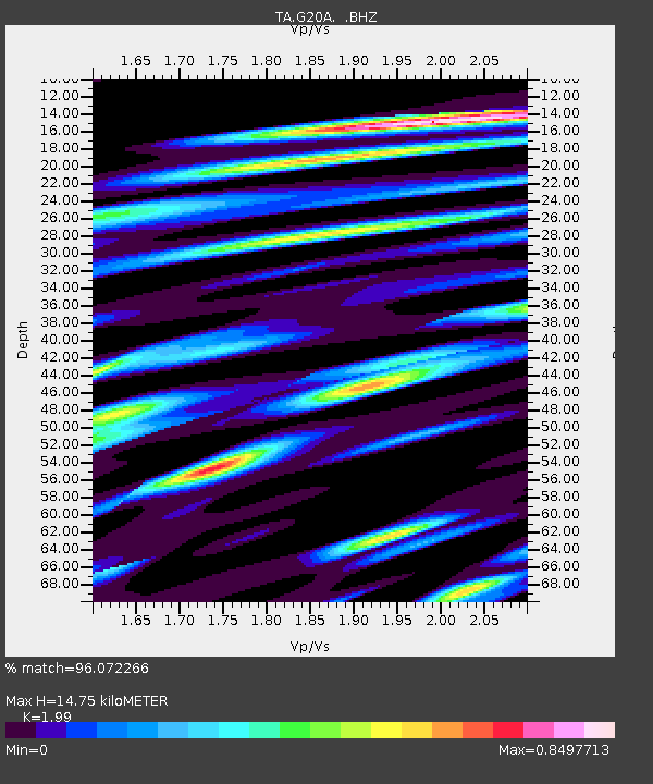
| Estimated Moho Depth: |
14.75 km |
| Estimated Crust Vp/Vs: |
1.99 |
| Assumed Crust Vp: |
6.242 km/s |
| Estimated Crust Vs: |
3.137 km/s |
| Estimated Crust Poisson's Ratio: |
0.33 |
|
| Radial Match: |
96.072266 % |
| Radial Bump: |
386 |
| Transverse Match: |
83.841095 % |
| Transverse Bump: |
400 |
| SOD ConfigId: |
2622 |
| Insert Time: |
2010-03-06 08:31:35.815 +0000 |
| GWidth: |
2.5 |
| Max Bumps: |
400 |
| Tol: |
0.001 |
|

Signal To Noise
| Channel | StoN | STA | LTA |
| TA:G20A: :BHZ:20090912T20:14:37.925005Z | 7.728693 | 8.970889E-7 | 1.1607253E-7 |
| TA:G20A: :BHN:20090912T20:14:37.925005Z | 3.2226024 | 3.4348514E-7 | 1.0658627E-7 |
| TA:G20A: :BHE:20090912T20:14:37.925005Z | 4.2840433 | 5.9136664E-7 | 1.3803937E-7 |
| Arrivals |
| Ps | 2.5 SECOND |
| PpPs | 6.7 SECOND |
| PsPs/PpSs | 9.2 SECOND |


