You are here: Home > Network List > TA - USArray Transportable Network (new EarthScope stations) Stations List
> Station G20A Bridger, MT, USA > Earthquake Result Viewer
G20A Bridger, MT, USA - Earthquake Result Viewer
| Earthquake location: |
Samoa Islands Region |
| Earthquake latitude/longitude: |
-15.5/-172.1 |
| Earthquake time(UTC): |
2009/09/29 (272) 17:48:10 GMT |
| Earthquake Depth: |
18 km |
| Earthquake Magnitude: |
7.1 MB, 8.1 MS, 8.1 MW, 8.0 MW |
| Earthquake Catalog/Contributor: |
WHDF/NEIC |
|
| Network: |
TA USArray Transportable Network (new EarthScope stations) |
| Station: |
G20A Bridger, MT, USA |
| Lat/Lon: |
45.22 N/108.21 W |
| Elevation: |
1431 m |
|
| Distance: |
83.6 deg |
| Az: |
39.689 deg |
| Baz: |
240.597 deg |
| Ray Param: |
0.046090133 |
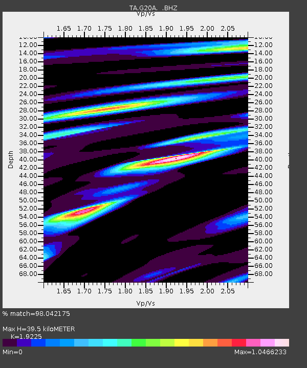
| Estimated Moho Depth: |
39.5 km |
| Estimated Crust Vp/Vs: |
1.92 |
| Assumed Crust Vp: |
6.242 km/s |
| Estimated Crust Vs: |
3.247 km/s |
| Estimated Crust Poisson's Ratio: |
0.31 |
|
| Radial Match: |
98.042175 % |
| Radial Bump: |
400 |
| Transverse Match: |
85.73837 % |
| Transverse Bump: |
400 |
| SOD ConfigId: |
2622 |
| Insert Time: |
2010-03-06 08:31:38.332 +0000 |
| GWidth: |
2.5 |
| Max Bumps: |
400 |
| Tol: |
0.001 |
|

Signal To Noise
| Channel | StoN | STA | LTA |
| TA:G20A: :BHZ:20090929T18:00:06.424021Z | 16.85792 | 3.166508E-6 | 1.8783503E-7 |
| TA:G20A: :BHN:20090929T18:00:06.424021Z | 6.7444005 | 6.723945E-7 | 9.9696706E-8 |
| TA:G20A: :BHE:20090929T18:00:06.424021Z | 10.668214 | 9.414966E-7 | 8.82525E-8 |
| Arrivals |
| Ps | 6.0 SECOND |
| PpPs | 18 SECOND |
| PsPs/PpSs | 24 SECOND |


