You are here: Home > Network List > TA - USArray Transportable Network (new EarthScope stations) Stations List
> Station G20A Bridger, MT, USA > Earthquake Result Viewer
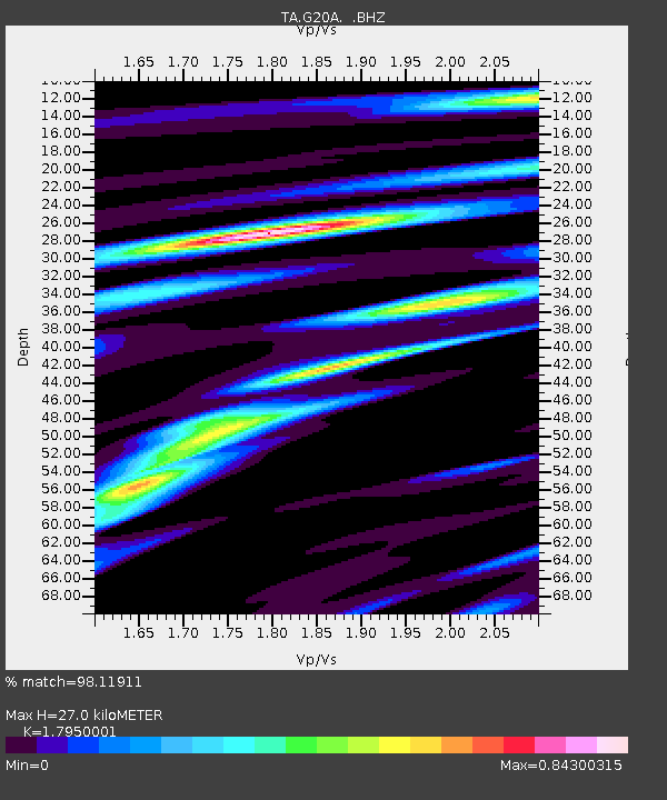
G20A Bridger, MT, USA - Earthquake Result Viewer
| Earthquake location: |
Tonga Islands Region |
| Earthquake latitude/longitude: |
-23.0/-174.7 |
| Earthquake time(UTC): |
2009/03/19 (078) 18:17:40 GMT |
| Earthquake Depth: |
34 km |
| Earthquake Magnitude: |
7.0 MB, 7.6 MS, 7.6 MW, 7.6 MW |
| Earthquake Catalog/Contributor: |
WHDF/NEIC |
|
| Network: |
TA USArray Transportable Network (new EarthScope stations) |
| Station: |
G20A Bridger, MT, USA |
| Lat/Lon: |
45.22 N/108.21 W |
| Elevation: |
1431 m |
|
| Distance: |
90.9 deg |
| Az: |
40.387 deg |
| Baz: |
237.616 deg |
| Ray Param: |
0.04163833 |
| Estimated Moho Depth: |
27.0 km |
| Estimated Crust Vp/Vs: |
1.80 |
| Assumed Crust Vp: |
6.242 km/s |
| Estimated Crust Vs: |
3.477 km/s |
| Estimated Crust Poisson's Ratio: |
0.27 |
|
| Radial Match: |
98.11911 % |
| Radial Bump: |
400 |
| Transverse Match: |
84.95028 % |
| Transverse Bump: |
400 |
| SOD ConfigId: |
2658 |
| Insert Time: |
2010-03-06 08:32:11.609 +0000 |
| GWidth: |
2.5 |
| Max Bumps: |
400 |
| Tol: |
0.001 |
|

Signal To Noise
| Channel | StoN | STA | LTA |
| TA:G20A: :BHZ:20090319T18:30:09.675015Z | 17.255854 | 3.6633069E-6 | 2.1229357E-7 |
| TA:G20A: :BHN:20090319T18:30:09.675015Z | 10.59458 | 8.1477725E-7 | 7.690511E-8 |
| TA:G20A: :BHE:20090319T18:30:09.675015Z | 9.072655 | 9.335003E-7 | 1.0289165E-7 |
| Arrivals |
| Ps | 3.5 SECOND |
| PpPs | 12 SECOND |
| PsPs/PpSs | 15 SECOND |


