You are here: Home > Network List > TA - USArray Transportable Network (new EarthScope stations) Stations List
> Station A21K Barrow, AK, USA > Earthquake Result Viewer
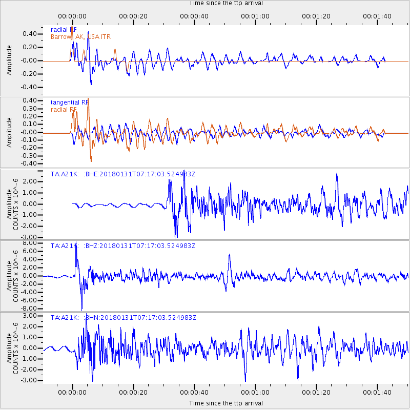
A21K Barrow, AK, USA - Earthquake Result Viewer
*The percent match for this event was below the threshold and hence no stack was calculated.
| Earthquake location: |
Hindu Kush Region, Afghanistan |
| Earthquake latitude/longitude: |
36.5/70.8 |
| Earthquake time(UTC): |
2018/01/31 (031) 07:07:00 GMT |
| Earthquake Depth: |
191 km |
| Earthquake Magnitude: |
6.1 Mww |
| Earthquake Catalog/Contributor: |
NEIC PDE/us |
|
| Network: |
TA USArray Transportable Network (new EarthScope stations) |
| Station: |
A21K Barrow, AK, USA |
| Lat/Lon: |
71.32 N/156.62 W |
| Elevation: |
577 m |
|
| Distance: |
67.3 deg |
| Az: |
14.903 deg |
| Baz: |
319.995 deg |
| Ray Param: |
$rayparam |
*The percent match for this event was below the threshold and hence was not used in the summary stack. |
|
| Radial Match: |
84.25623 % |
| Radial Bump: |
400 |
| Transverse Match: |
88.245636 % |
| Transverse Bump: |
400 |
| SOD ConfigId: |
13570011 |
| Insert Time: |
2019-04-29 16:50:45.364 +0000 |
| GWidth: |
2.5 |
| Max Bumps: |
400 |
| Tol: |
0.001 |
|
Signal To Noise
| Channel | StoN | STA | LTA |
| TA:A21K: :BHZ:20180131T07:17:03.524983Z | 18.483643 | 3.050256E-6 | 1.6502462E-7 |
| TA:A21K: :BHN:20180131T07:17:03.524983Z | 7.36112 | 9.708839E-7 | 1.3189349E-7 |
| TA:A21K: :BHE:20180131T07:17:03.524983Z | 10.782462 | 1.2242399E-6 | 1.1353992E-7 |
| Arrivals |
| Ps | |
| PpPs | |
| PsPs/PpSs | |


