You are here: Home > Network List > TA - USArray Transportable Network (new EarthScope stations) Stations List
> Station G31M Satah River, YT, CAN > Earthquake Result Viewer
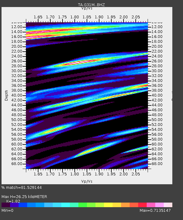
G31M Satah River, YT, CAN - Earthquake Result Viewer
| Earthquake location: |
Hindu Kush Region, Afghanistan |
| Earthquake latitude/longitude: |
36.5/70.8 |
| Earthquake time(UTC): |
2018/01/31 (031) 07:07:00 GMT |
| Earthquake Depth: |
191 km |
| Earthquake Magnitude: |
6.1 Mww |
| Earthquake Catalog/Contributor: |
NEIC PDE/us |
|
| Network: |
TA USArray Transportable Network (new EarthScope stations) |
| Station: |
G31M Satah River, YT, CAN |
| Lat/Lon: |
66.92 N/134.27 W |
| Elevation: |
61 m |
|
| Distance: |
75.1 deg |
| Az: |
9.96 deg |
| Baz: |
339.308 deg |
| Ray Param: |
0.05140163 |
| Estimated Moho Depth: |
26.25 km |
| Estimated Crust Vp/Vs: |
1.82 |
| Assumed Crust Vp: |
6.171 km/s |
| Estimated Crust Vs: |
3.391 km/s |
| Estimated Crust Poisson's Ratio: |
0.28 |
|
| Radial Match: |
81.529144 % |
| Radial Bump: |
400 |
| Transverse Match: |
77.30548 % |
| Transverse Bump: |
400 |
| SOD ConfigId: |
13570011 |
| Insert Time: |
2019-04-29 16:51:29.320 +0000 |
| GWidth: |
2.5 |
| Max Bumps: |
400 |
| Tol: |
0.001 |
|

Signal To Noise
| Channel | StoN | STA | LTA |
| TA:G31M: :BHZ:20180131T07:17:50.024983Z | 10.0985 | 3.2106427E-6 | 3.1793263E-7 |
| TA:G31M: :BHN:20180131T07:17:50.024983Z | 4.63834 | 1.4699268E-6 | 3.1690794E-7 |
| TA:G31M: :BHE:20180131T07:17:50.024983Z | 3.596364 | 9.3086686E-7 | 2.5883554E-7 |
| Arrivals |
| Ps | 3.6 SECOND |
| PpPs | 12 SECOND |
| PsPs/PpSs | 15 SECOND |


