You are here: Home > Network List > TA - USArray Transportable Network (new EarthScope stations) Stations List
> Station J25K Salcha River, AK, USA > Earthquake Result Viewer
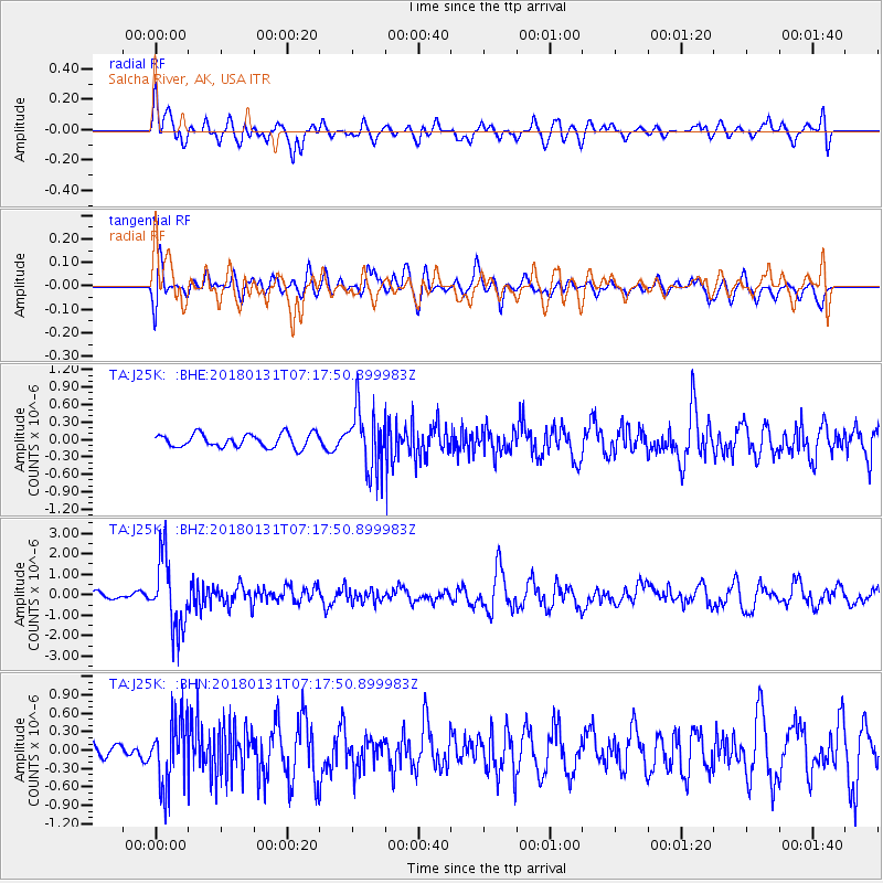
J25K Salcha River, AK, USA - Earthquake Result Viewer
*The percent match for this event was below the threshold and hence no stack was calculated.
| Earthquake location: |
Hindu Kush Region, Afghanistan |
| Earthquake latitude/longitude: |
36.5/70.8 |
| Earthquake time(UTC): |
2018/01/31 (031) 07:07:00 GMT |
| Earthquake Depth: |
191 km |
| Earthquake Magnitude: |
6.1 Mww |
| Earthquake Catalog/Contributor: |
NEIC PDE/us |
|
| Network: |
TA USArray Transportable Network (new EarthScope stations) |
| Station: |
J25K Salcha River, AK, USA |
| Lat/Lon: |
64.61 N/145.37 W |
| Elevation: |
949 m |
|
| Distance: |
75.2 deg |
| Az: |
15.26 deg |
| Baz: |
330.549 deg |
| Ray Param: |
$rayparam |
*The percent match for this event was below the threshold and hence was not used in the summary stack. |
|
| Radial Match: |
61.44539 % |
| Radial Bump: |
400 |
| Transverse Match: |
66.15793 % |
| Transverse Bump: |
400 |
| SOD ConfigId: |
13570011 |
| Insert Time: |
2019-04-29 16:51:48.399 +0000 |
| GWidth: |
2.5 |
| Max Bumps: |
400 |
| Tol: |
0.001 |
|
Signal To Noise
| Channel | StoN | STA | LTA |
| TA:J25K: :BHZ:20180131T07:17:50.899983Z | 9.415968 | 1.7248121E-6 | 1.831795E-7 |
| TA:J25K: :BHN:20180131T07:17:50.899983Z | 3.2103195 | 5.47691E-7 | 1.7060327E-7 |
| TA:J25K: :BHE:20180131T07:17:50.899983Z | 4.3688674 | 5.0563693E-7 | 1.1573639E-7 |
| Arrivals |
| Ps | |
| PpPs | |
| PsPs/PpSs | |


