You are here: Home > Network List > TA - USArray Transportable Network (new EarthScope stations) Stations List
> Station K15K Wolf Creek Mountain, AK, USA > Earthquake Result Viewer
K15K Wolf Creek Mountain, AK, USA - Earthquake Result Viewer
| Earthquake location: |
Hindu Kush Region, Afghanistan |
| Earthquake latitude/longitude: |
36.5/70.8 |
| Earthquake time(UTC): |
2018/01/31 (031) 07:07:00 GMT |
| Earthquake Depth: |
191 km |
| Earthquake Magnitude: |
6.1 Mww |
| Earthquake Catalog/Contributor: |
NEIC PDE/us |
|
| Network: |
TA USArray Transportable Network (new EarthScope stations) |
| Station: |
K15K Wolf Creek Mountain, AK, USA |
| Lat/Lon: |
62.29 N/161.53 W |
| Elevation: |
346 m |
|
| Distance: |
72.9 deg |
| Az: |
22.779 deg |
| Baz: |
318.156 deg |
| Ray Param: |
0.052854218 |
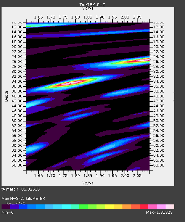
| Estimated Moho Depth: |
34.5 km |
| Estimated Crust Vp/Vs: |
1.78 |
| Assumed Crust Vp: |
6.276 km/s |
| Estimated Crust Vs: |
3.531 km/s |
| Estimated Crust Poisson's Ratio: |
0.27 |
|
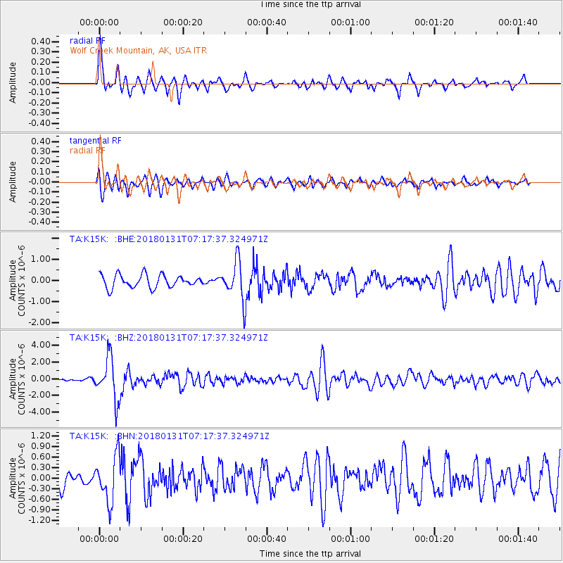
| Radial Match: |
86.32636 % |
| Radial Bump: |
400 |
| Transverse Match: |
65.83996 % |
| Transverse Bump: |
400 |
| SOD ConfigId: |
13570011 |
| Insert Time: |
2019-04-29 16:51:51.469 +0000 |
| GWidth: |
2.5 |
| Max Bumps: |
400 |
| Tol: |
0.001 |
|
Signal To Noise
| Channel | StoN | STA | LTA |
| TA:K15K: :BHZ:20180131T07:17:37.324971Z | 21.141172 | 2.6208702E-6 | 1.2396995E-7 |
| TA:K15K: :BHN:20180131T07:17:37.324971Z | 2.7189472 | 6.729152E-7 | 2.474911E-7 |
| TA:K15K: :BHE:20180131T07:17:37.324971Z | 3.1171558 | 9.399112E-7 | 3.0152847E-7 |
| Arrivals |
| Ps | 4.4 SECOND |
| PpPs | 15 SECOND |
| PsPs/PpSs | 19 SECOND |


