You are here: Home > Network List > TA - USArray Transportable Network (new EarthScope stations) Stations List
> Station L15K Ungalak Mountain, AK, USA > Earthquake Result Viewer
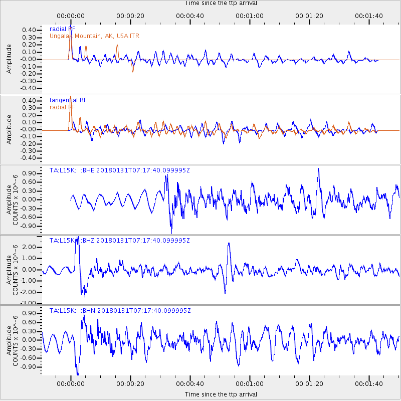
L15K Ungalak Mountain, AK, USA - Earthquake Result Viewer
*The percent match for this event was below the threshold and hence no stack was calculated.
| Earthquake location: |
Hindu Kush Region, Afghanistan |
| Earthquake latitude/longitude: |
36.5/70.8 |
| Earthquake time(UTC): |
2018/01/31 (031) 07:07:00 GMT |
| Earthquake Depth: |
191 km |
| Earthquake Magnitude: |
6.1 Mww |
| Earthquake Catalog/Contributor: |
NEIC PDE/us |
|
| Network: |
TA USArray Transportable Network (new EarthScope stations) |
| Station: |
L15K Ungalak Mountain, AK, USA |
| Lat/Lon: |
61.68 N/161.49 W |
| Elevation: |
219 m |
|
| Distance: |
73.4 deg |
| Az: |
23.193 deg |
| Baz: |
318.315 deg |
| Ray Param: |
$rayparam |
*The percent match for this event was below the threshold and hence was not used in the summary stack. |
|
| Radial Match: |
67.74938 % |
| Radial Bump: |
315 |
| Transverse Match: |
62.7995 % |
| Transverse Bump: |
345 |
| SOD ConfigId: |
13570011 |
| Insert Time: |
2019-04-29 16:51:56.897 +0000 |
| GWidth: |
2.5 |
| Max Bumps: |
400 |
| Tol: |
0.001 |
|
Signal To Noise
| Channel | StoN | STA | LTA |
| TA:L15K: :BHZ:20180131T07:17:40.099995Z | 10.14732 | 1.6031788E-6 | 1.5799037E-7 |
| TA:L15K: :BHN:20180131T07:17:40.099995Z | 1.9500362 | 5.9510796E-7 | 3.051779E-7 |
| TA:L15K: :BHE:20180131T07:17:40.099995Z | 2.9524603 | 4.8535935E-7 | 1.643915E-7 |
| Arrivals |
| Ps | |
| PpPs | |
| PsPs/PpSs | |


