You are here: Home > Network List > IU - Global Seismograph Network (GSN - IRIS/USGS) Stations List
> Station RSSD Black Hills, South Dakota, USA > Earthquake Result Viewer
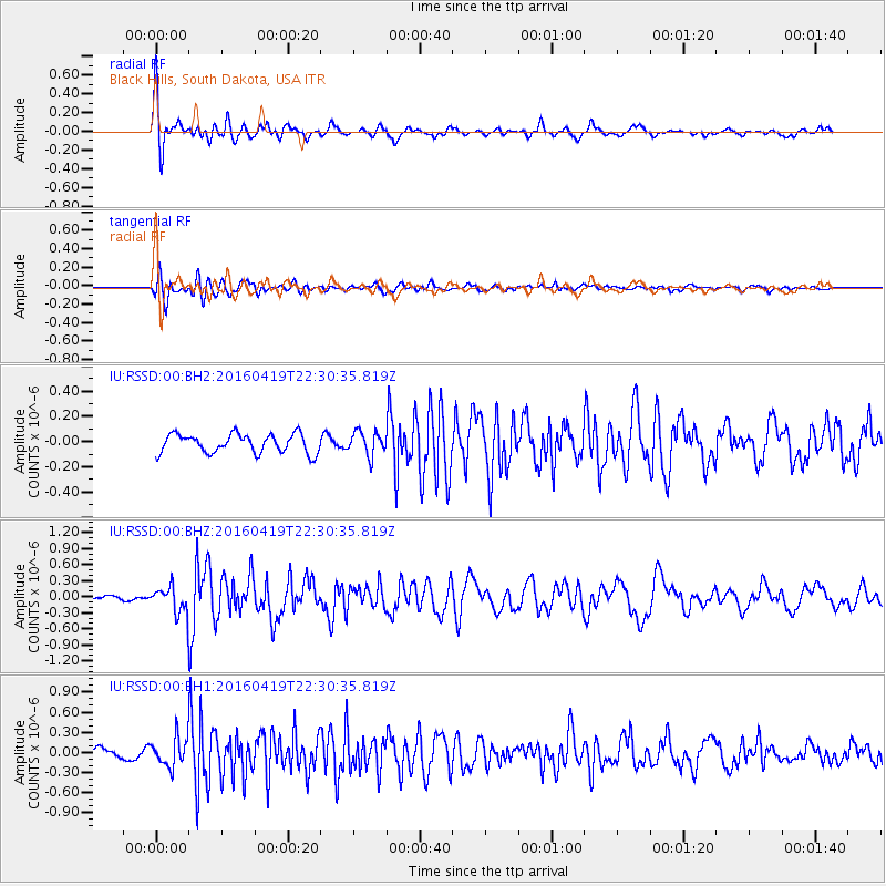
RSSD Black Hills, South Dakota, USA - Earthquake Result Viewer
*The percent match for this event was below the threshold and hence no stack was calculated.
| Earthquake location: |
Near Coast Of Ecuador |
| Earthquake latitude/longitude: |
0.6/-80.1 |
| Earthquake time(UTC): |
2016/04/19 (110) 22:22:26 GMT |
| Earthquake Depth: |
15 km |
| Earthquake Magnitude: |
5.5 MB |
| Earthquake Catalog/Contributor: |
NEIC PDE/NEIC ALERT |
|
| Network: |
IU Global Seismograph Network (GSN - IRIS/USGS) |
| Station: |
RSSD Black Hills, South Dakota, USA |
| Lat/Lon: |
44.12 N/104.04 W |
| Elevation: |
2090 m |
|
| Distance: |
48.3 deg |
| Az: |
336.933 deg |
| Baz: |
147.044 deg |
| Ray Param: |
$rayparam |
*The percent match for this event was below the threshold and hence was not used in the summary stack. |
|
| Radial Match: |
78.521706 % |
| Radial Bump: |
400 |
| Transverse Match: |
76.67712 % |
| Transverse Bump: |
400 |
| SOD ConfigId: |
1475611 |
| Insert Time: |
2016-05-03 22:32:09.798 +0000 |
| GWidth: |
2.5 |
| Max Bumps: |
400 |
| Tol: |
0.001 |
|
Signal To Noise
| Channel | StoN | STA | LTA |
| IU:RSSD:00:BHZ:20160419T22:30:35.819Z | 3.1820366 | 2.4159584E-7 | 7.592491E-8 |
| IU:RSSD:00:BH1:20160419T22:30:35.819Z | 2.90118 | 2.1078358E-7 | 7.265443E-8 |
| IU:RSSD:00:BH2:20160419T22:30:35.819Z | 1.2628156 | 9.46969E-8 | 7.4988705E-8 |
| Arrivals |
| Ps | |
| PpPs | |
| PsPs/PpSs | |


