You are here: Home > Network List > TA - USArray Transportable Network (new EarthScope stations) Stations List
> Station Q17K Contact Creek, Katmai, AK, USA > Earthquake Result Viewer
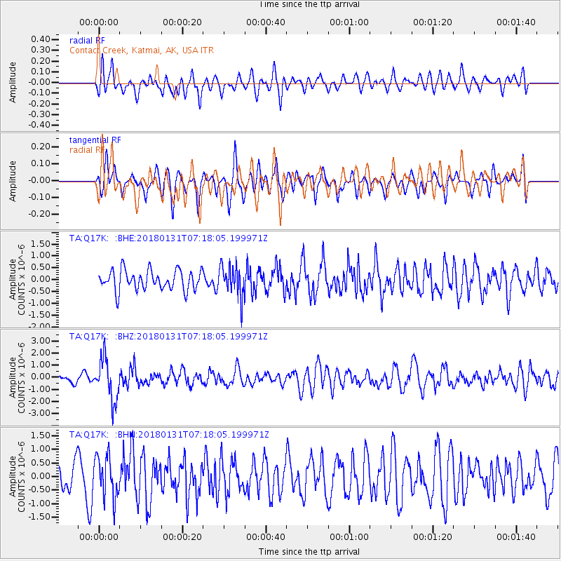
Q17K Contact Creek, Katmai, AK, USA - Earthquake Result Viewer
*The percent match for this event was below the threshold and hence no stack was calculated.
| Earthquake location: |
Hindu Kush Region, Afghanistan |
| Earthquake latitude/longitude: |
36.5/70.8 |
| Earthquake time(UTC): |
2018/01/31 (031) 07:07:00 GMT |
| Earthquake Depth: |
191 km |
| Earthquake Magnitude: |
6.1 Mww |
| Earthquake Catalog/Contributor: |
NEIC PDE/us |
|
| Network: |
TA USArray Transportable Network (new EarthScope stations) |
| Station: |
Q17K Contact Creek, Katmai, AK, USA |
| Lat/Lon: |
58.26 N/155.89 W |
| Elevation: |
1165 m |
|
| Distance: |
77.8 deg |
| Az: |
23.177 deg |
| Baz: |
323.155 deg |
| Ray Param: |
$rayparam |
*The percent match for this event was below the threshold and hence was not used in the summary stack. |
|
| Radial Match: |
48.739788 % |
| Radial Bump: |
400 |
| Transverse Match: |
45.6981 % |
| Transverse Bump: |
383 |
| SOD ConfigId: |
13570011 |
| Insert Time: |
2019-04-29 16:52:41.168 +0000 |
| GWidth: |
2.5 |
| Max Bumps: |
400 |
| Tol: |
0.001 |
|
Signal To Noise
| Channel | StoN | STA | LTA |
| TA:Q17K: :BHZ:20180131T07:18:05.199971Z | 3.6422303 | 1.7237859E-6 | 4.732776E-7 |
| TA:Q17K: :BHN:20180131T07:18:05.199971Z | 1.4964858 | 7.8286297E-7 | 5.2313425E-7 |
| TA:Q17K: :BHE:20180131T07:18:05.199971Z | 1.5354233 | 6.392666E-7 | 4.1634553E-7 |
| Arrivals |
| Ps | |
| PpPs | |
| PsPs/PpSs | |


