You are here: Home > Network List > TA - USArray Transportable Network (new EarthScope stations) Stations List
> Station R32K Eaglecrest, AK, USA > Earthquake Result Viewer
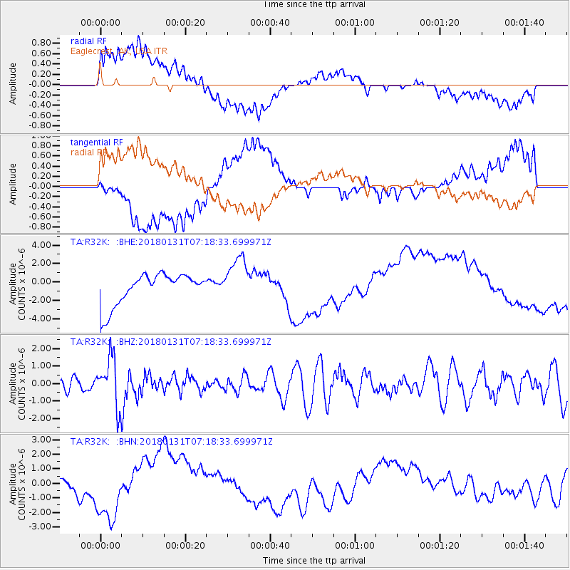
R32K Eaglecrest, AK, USA - Earthquake Result Viewer
*The percent match for this event was below the threshold and hence no stack was calculated.
| Earthquake location: |
Hindu Kush Region, Afghanistan |
| Earthquake latitude/longitude: |
36.5/70.8 |
| Earthquake time(UTC): |
2018/01/31 (031) 07:07:00 GMT |
| Earthquake Depth: |
191 km |
| Earthquake Magnitude: |
6.1 Mww |
| Earthquake Catalog/Contributor: |
NEIC PDE/us |
|
| Network: |
TA USArray Transportable Network (new EarthScope stations) |
| Station: |
R32K Eaglecrest, AK, USA |
| Lat/Lon: |
58.27 N/134.52 W |
| Elevation: |
386 m |
|
| Distance: |
83.2 deg |
| Az: |
13.162 deg |
| Baz: |
339.694 deg |
| Ray Param: |
$rayparam |
*The percent match for this event was below the threshold and hence was not used in the summary stack. |
|
| Radial Match: |
27.464384 % |
| Radial Bump: |
400 |
| Transverse Match: |
29.773294 % |
| Transverse Bump: |
400 |
| SOD ConfigId: |
13570011 |
| Insert Time: |
2019-04-29 16:52:45.420 +0000 |
| GWidth: |
2.5 |
| Max Bumps: |
400 |
| Tol: |
0.001 |
|
Signal To Noise
| Channel | StoN | STA | LTA |
| TA:R32K: :BHZ:20180131T07:18:33.699971Z | 4.337482 | 1.4605818E-6 | 3.3673496E-7 |
| TA:R32K: :BHN:20180131T07:18:33.699971Z | 1.775507 | 1.6830655E-6 | 9.479352E-7 |
| TA:R32K: :BHE:20180131T07:18:33.699971Z | 1.5055923 | 2.5562072E-6 | 1.6978082E-6 |
| Arrivals |
| Ps | |
| PpPs | |
| PsPs/PpSs | |


